Crouse, Elbert, Farmstead

Why it's listed
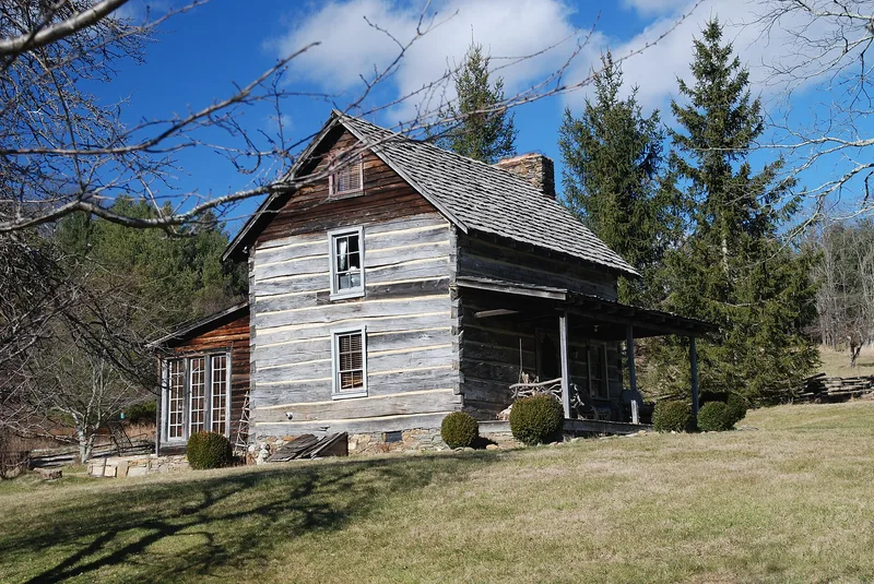
Located on the crest of the Blue Ridge in southwestern Alleghany County, this 139-acre farm once supported a family of subsistence growers in a remote part of the western North Carolina mountains. The centerpiece is a small log dwelling with a two-room plan, square-hewn logs joined by half-dovetail notching, and a steeply pitched tin roof. Its construction date is uncertain, with accounts placing it around 1905 or as early as the 1870s. A frame barn, probably from the 1920s or 1930s, and a few other outbuildings survive alongside ruins. Bettie Wady Crouse planted an orchard and ornamental trees, including apples, peaches, black walnuts, and chestnuts, that gave the household food and income. The farm is regarded as an example of the log building tradition persisting into the twentieth century and of the self-sufficient mountain life that was largely gone by the time the site was studied. The Blue Ridge Parkway now borders the property.
Significance in brief: The nomination argues the farm represents the small, self-sufficient family farms of remote western North Carolina mountains. Its log house shows the persistence of the log building tradition into the late nineteenth or early twentieth century. The orchard and ornamental plantings reflect the household's food and income sources, and the site is said to offer information on Southern Appalachian folkways.
Machine-generated summary. This summary was generated by a language model from the official nomination document and has not been reviewed line by line by an editor. It may contain errors. Check the source document before relying on any detail. Source: nomination document (PDF) · National Archives catalog entry. NRHP reference 82003423, listed July 29, 1982. Summary generated October 2026 (model claude-haiku-5-5, prompt v1.1-2026-10-29, confidence medium).
Key facts
| Address | S of Whitehead on Blue Ridge Parkway, Whitehead |
|---|---|
| County | Alleghany County |
| Listed | July 29, 1982 |
| Reference number | 82003423 |
| Resource type | Building |
| Period of significance | 1800-1899, 1900- |
| Criteria |
|
| Areas of significance | Agriculture, Architecture |
| Level of significance | Local |
| Status (as stated in the nomination) | Deteriorated and altered; the farm is abandoned and its orchard has been untended for over a decade. |
| Acreage | 139 |
| Coordinates | 36.42968, -81.15028 (NPS GIS) |
What listing means for this property
National Register listing is honorary for a privately owned home: it does not by itself restrict what an owner may do with their own money, and it does not require public access. Restrictions come from local landmark or historic-district ordinances, which are separate (how they differ).
Owner-occupied houses are not eligible for the 20% federal rehabilitation tax credit, which applies to income-producing buildings, but many states offer credits for homeowners. Listing also opens the door to preservation easements and to buying a plaque. Start with what listing means for homeowners, renovating a listed house and selling one.
Noted as vacant in the nomination. Nomination documents can be decades old; current status may differ. If you are considering buying an empty listed property, read the due-diligence checklist.
General information, not legal or tax advice. Rules change; confirm with your State Historic Preservation Office or a qualified adviser.
Sources and further reading
- National Park Service, National Register of Historic Places database (snapshot May 2026), reference 82003423.
- Nomination form (PDF, National Archives) — catalog entry
- Wikipedia article (used for cross-checking only; text not reproduced here)
- Wikidata Q17508408
- This listing as JSON
Last updated October 2026. Found an error? See the editorial policy for how to report it.