Latimer Reef Light Station

Approximate location: the National Park Service places this pin arbitrarily within the property, not at a surveyed point (stated accuracy ±12 m).
Why it's listed
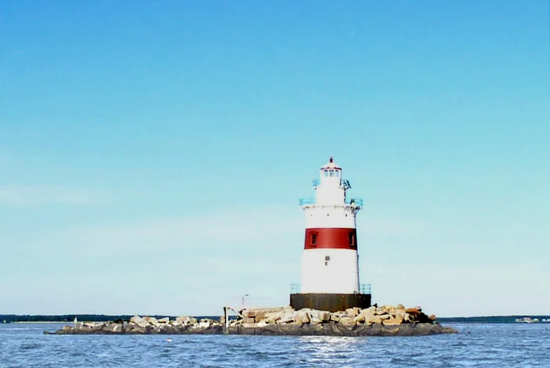
Latimer Reef Light Station is a cast-iron lighthouse completed in 1884 in about 18 feet of water at the western end of Latimer Reef, roughly one mile north-northwest of East Point on Fishers Island. It belongs to the "sparkplug" type, named for its resemblance to a spark plug seen from afar. A 30-foot brown caisson filled with concrete and ringed by riprap supports a 46-foot superstructure: a four-story conical tower, a cylindrical watch room and a ten-sided lantern. The interior is lined with brick up to the third story, and a winding cast-iron stair rises through the tower. Over time the iron awning, smoke stack, fog bell, coal bin shed and privy have disappeared, and modern fixtures have been added. Resident keepers lived at the station until it was automated in 1974. Its significance rests on its role in maritime history and transportation, with architecture and engineering also noted, between 1884 and 1954. It remains an active aid to navigation owned by the Coast Guard.
Significance in brief: The nomination marks it significant under Criterion A in maritime history and transportation, with architecture and engineering also listed as areas of significance. It served as a manned aid to navigation from 1884 until automation in 1974, and it survives as an example of the sparkplug lighthouse type built by the U.S. Lighthouse Board.
Machine-generated summary. This summary was generated by a language model from the official nomination document and has not been reviewed line by line by an editor. It may contain errors. Check the source document before relying on any detail. Source: nomination document (PDF) · National Archives catalog entry. NRHP reference 06000635, listed July 19, 2006. Summary generated October 2026 (model claude-sonnet-5-5, prompt v1.0-2026-10-29, confidence medium).
Key facts
| Address | In Fisher's Island Sound, one mi NW of East Point on Fisher's Island, Fisher's Island |
|---|---|
| County | Suffolk County |
| Listed | July 19, 2006 |
| Reference number | 06000635 |
| Resource type | Building |
| Period of significance | 1884-1954 |
| Architect / builder | U.S. Lighthouse Board |
| Architectural style | No Style |
| Criteria |
|
| Areas of significance | Maritime History, Transportation, Architecture, Engineering |
| Level of significance | Local |
| Status (as stated in the nomination) | Active aid to navigation owned by the U.S. Coast Guard; automated in 1974 and reachable only by boat. |
| Acreage | 0.9 |
| Coordinates | 41.30446, -71.93332 (NPS GIS) |
What listing means for this property
For a publicly owned building or structure, listing mainly matters when federal funds, permits or licences are involved: projects then go through Section 106 review so effects on the property are considered. Listing also strengthens applications for preservation grants and, for leased income-producing uses, can enable the federal rehabilitation tax credit.
General information, not legal or tax advice. Rules change; confirm with your State Historic Preservation Office or a qualified adviser.
Sources and further reading
- National Park Service, National Register of Historic Places database (snapshot May 2026), reference 06000635.
- Nomination form (PDF, National Archives) — catalog entry
- Wikipedia article (used for cross-checking only; text not reproduced here)
- Wikidata Q6496156
- This listing as JSON
Last updated October 2026. Found an error? See the editorial policy for how to report it.