Cedar Island Lighthouse
Also known as: Cedar Island Light Station

Why it's listed
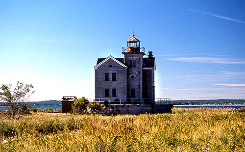
Cedar Island Lighthouse marks the entrance to Northwest Harbor and Sag Harbor from Gardiner's Bay. Begun in 1868 and finished in 1869, it replaced an earlier 1839 light on an eroding sandy island, which a 1938 hurricane later joined to the mainland as Cedar Point. The building is an L-shaped, two-story granite keeper's residence with a three-story square tower and cast iron lantern, set on a circular granite base. A small brick oil house stands nearby. It was one of several granite lights built by the Third Lighthouse District after the Civil War, and it served whaling ships and Sag Harbor's maritime trade. Its L-shaped plan for a sixth-order lens appears to be unique among eastern Long Island lighthouses. The light was decommissioned in 1934 and Suffolk County acquired it in 1967. A 1974 fire destroyed the interior and roof, but the granite exterior, tower and lantern remain.
Significance in brief: It is significant as part of the federal aids-to-navigation system serving eastern Long Island and the whaling and maritime trade of Sag Harbor. It represents the Third Lighthouse District's post-Civil War upgrade and standardization of granite lighthouses. It appears to be the sole example of the sixth-order lighthouse type in eastern Long Island.
Machine-generated summary. This summary was generated by a language model from the official nomination document and has not been reviewed line by line by an editor. It may contain errors. Check the source document before relying on any detail. Source: nomination document (PDF) · National Archives catalog entry. NRHP reference 03000248, listed April 18, 2003. Summary generated October 2026 (model claude-sonnet-5-5, prompt v1.0-2026-10-29, confidence high).
Key facts
| Address | Cedar Point Rd., Sag Harbor |
|---|---|
| County | Suffolk County |
| Listed | April 18, 2003 |
| Reference number | 03000248 |
| Resource type | Building |
| Period of significance | 1868 |
| Architectural style | Mid-Nineteenth Century: Italian Villa |
| Criteria |
|
| Areas of significance | Architecture, Maritime History |
| Level of significance | Local |
| Status (as stated in the nomination) | Gutted by fire in 1974; the interior is open with temporary supports, the windows and entries are infilled with concrete block, and the oil house is in poor condition. The form lists the current function as vacant/not in use. |
| Acreage | 1.5 |
| Coordinates | 41.04069, -72.26042 (NPS GIS) |
What listing means for this property
For a publicly owned building or structure, listing mainly matters when federal funds, permits or licences are involved: projects then go through Section 106 review so effects on the property are considered. Listing also strengthens applications for preservation grants and, for leased income-producing uses, can enable the federal rehabilitation tax credit.
Noted as vacant in the nomination. Nomination documents can be decades old; current status may differ. If you are considering buying an empty listed property, read the due-diligence checklist.
General information, not legal or tax advice. Rules change; confirm with your State Historic Preservation Office or a qualified adviser.
Sources and further reading
- National Park Service, National Register of Historic Places database (snapshot May 2026), reference 03000248.
- Nomination form (PDF, National Archives) — catalog entry
- Wikipedia article (used for cross-checking only; text not reproduced here)
- Wikidata Q15208218
- This listing as JSON
Last updated October 2026. Found an error? See the editorial policy for how to report it.