Schodack Landing Historic District

Why it's listed
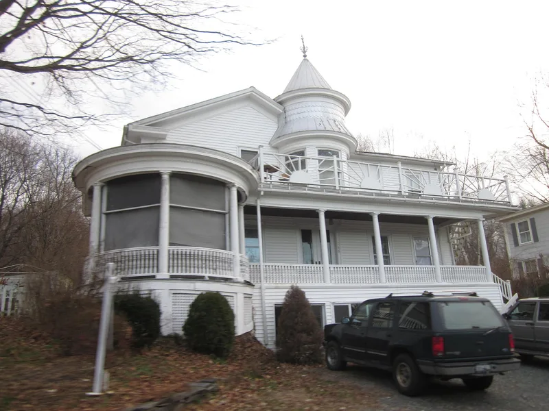
Schodack Landing is a small riverside hamlet on the east bank of the Hudson River in Rensselaer County, New York. The historic district covers about 205 acres and roughly 86 buildings, nearly all of them houses, along with a post office, two churches, a nursing home, a tavern and a store. Sixteen buildings are thought to predate 1790. Early examples include one and a half story homes with gable roofs and end chimneys, and several Dutch brick houses with gambrel roofs. Later houses add Federal detail, Italianate features, mansard roofs and bracketed Victorian porches. The settlement began with land leases granted in 1707 to related Dutch families, including the Schermerhorns, Barheyts and Van Burens. It grew into a trading community supplying inland stores and mills, then an export point for farm products, and later a site of Hudson River ice shipping. Little building took place in the twentieth century, so the hamlet keeps its early character and has few modern intrusions.
Significance in brief: The hamlet was settled by Dutch families in the early 1700s and became an important eighteenth and nineteenth century riverside trading and shipping community. It retains many old structures largely intact, along with the atmosphere of a nineteenth-century community. Its buildings include notable eighteenth-century Dutch brick houses and Victorian homes with decorative porches.
Machine-generated summary. This summary was generated by a language model from the official nomination document and has not been reviewed line by line by an editor. It may contain errors. Check the source document before relying on any detail. Source: nomination document (PDF) · National Archives catalog entry. NRHP reference 77000976, listed September 15, 1977. Summary generated October 2026 (model claude-sonnet-5-5, prompt v1.0-2026-10-29, confidence medium).
Key facts
| Address | NY 9J, Schodack Landing |
|---|---|
| County | Rensselaer County |
| Listed | September 15, 1977 |
| Reference number | 77000976 |
| Resource type | District |
| Architectural style | Dutch brick gambrel-roofed farmhouses, Federal, Greek Revival, Italianate, mansard and Queen Anne buildings, with Victorian porch detailing |
| Areas of significance | Commerce, Historic - Non-Aboriginal, Exploration/Settlement, Architecture |
| Level of significance | Local |
| Status (as stated in the nomination) | Described as occupied and partly unoccupied, in excellent to fair condition. It serves mainly as a bedroom community, with mostly residences plus a post office, two churches, a nursing home, a tavern and a store. |
| Acreage | 205 |
| Coordinates | 42.48303, -73.76805 (NPS GIS) |
What listing means for this property
This is a historic district. Buildings within its boundary are either contributing (they add to the district's significance) or non-contributing. Owners of contributing income-producing buildings can claim the 20% federal rehabilitation tax credit; homeowners should look at state credits. National Register districts impose no design review by themselves; a local historic district ordinance, if one exists, does (the difference explained).
General information, not legal or tax advice. Rules change; confirm with your State Historic Preservation Office or a qualified adviser.
Sources and further reading
- National Park Service, National Register of Historic Places database (snapshot May 2026), reference 77000976.
- Nomination form (PDF, National Archives) — catalog entry
- Wikipedia article (used for cross-checking only; text not reproduced here)
- Wikidata Q7431936
- This listing as JSON
Last updated October 2026. Found an error? See the editorial policy for how to report it.