Selkirk Lighthouse

Why it's listed
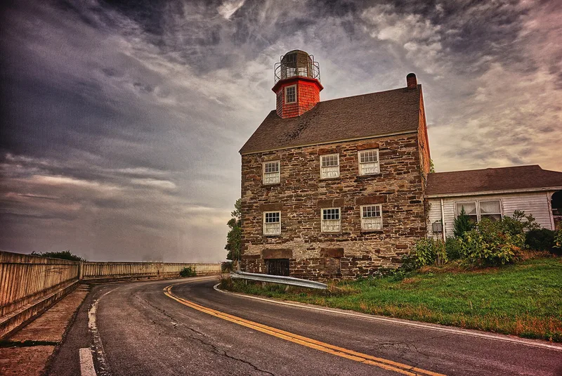
Overlooking the mouth of the Salmon River and Lake Ontario west of Pulaski, this two-story stone lighthouse was completed in 1838. A wood and wrought iron octagonal tower rises from the ridge of its gable roof, topped by a copper-domed iron lantern reached by a narrow spiral wooden stair. Inside, walls are lath and plaster and floors are wide pine boards. It was built when land speculators hoped to create a rival port called Port Ontario and persuaded the federal government to fund a pier and lighthouse. An economic depression, the lack of a railroad and silting of the river closed the port and lighthouse in 1839. In the late nineteenth century it became part of a resort, with a bar in the basement and a hotel built nearby in 1899. It later became a summer home and, from 1940, a year-round residence. It is the only remaining historic lighthouse in Oswego County.
Significance in brief: The nomination presents it as the only remaining historic lighthouse in Oswego County and a significant example of early nineteenth-century lighthouse technology. Its stonework, wood frame tower and wrought iron lantern make it an architectural landmark. It also recalls early maritime development on Lake Ontario and the later use of the site as a resort.
Machine-generated summary. This summary was generated by a language model from the official nomination document and has not been reviewed line by line by an editor. It may contain errors. Check the source document before relying on any detail. Source: nomination document (PDF) · National Archives catalog entry. NRHP reference 79001618, listed March 30, 1979. Summary generated October 2026 (model claude-sonnet-5-5, prompt v1.0-2026-10-29, confidence medium).
Key facts
| Address | W of Pulaski on Lake Rd., Pulaski |
|---|---|
| County | Oswego County |
| Listed | March 30, 1979 |
| Reference number | 79001618 |
| Resource type | Structure |
| Period of significance | 1838 |
| Areas of significance | Transportation, Architecture |
| Level of significance | Local |
| Status (as stated in the nomination) | Occupied as a private residence; a permanent family residence since 1940, with a 1972-73 kitchen addition. |
| Acreage | 0.9 |
| Coordinates | 43.57456, -76.20167 (NPS GIS) |
What listing means for this property
For a publicly owned building or structure, listing mainly matters when federal funds, permits or licences are involved: projects then go through Section 106 review so effects on the property are considered. Listing also strengthens applications for preservation grants and, for leased income-producing uses, can enable the federal rehabilitation tax credit.
General information, not legal or tax advice. Rules change; confirm with your State Historic Preservation Office or a qualified adviser.
Sources and further reading
- National Park Service, National Register of Historic Places database (snapshot May 2026), reference 79001618.
- Nomination form (PDF, National Archives) — catalog entry
- Wikipedia article (used for cross-checking only; text not reproduced here)
- Wikidata Q7448550
- This listing as JSON
Last updated October 2026. Found an error? See the editorial policy for how to report it.