Sheldon-Owens Farm

Why it's listed
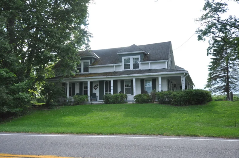
Sheldon-Owens Farm occupies about 251 acres in the southeast corner of Willsboro, Essex County, New York. Joseph Sheldon bought the first lot in 1784, and the farm grew through the nineteenth century before the Owens family acquired it in 1903 and expanded it again. Buildings cluster along Route 22, including an English-type barn from the late eighteenth century, later barns, a granary, a brick smokehouse, a sugar house, a well house with a windmill, and a farmhouse built about 1855 and remodeled around 1910-20. Behind them lie crop fields, pastures, a cow lane, a mature apple orchard and a woodlot, an arrangement that follows the New England four-field system. Dairy products, wool and apples remained staples of the farm economy into the mid-twentieth century. The farm is notable for the continuity of its layout and the survival of its buildings and landscape across more than two centuries, with little major change between 1950 and 1985.
Significance in brief: The farm illustrates more than two centuries of agricultural use, from a late eighteenth-century settlement-era farm through the early twentieth century. It retains its New England four-field layout, a cow lane, an orchard and a largely intact group of barns and outbuildings. Its well-documented history under the Sheldon, Hoffnagle and Owens families adds to its value.
Machine-generated summary. This summary was generated by a language model from the official nomination document and has not been reviewed line by line by an editor. It may contain errors. Check the source document before relying on any detail. Source: nomination document (PDF) · National Archives catalog entry. NRHP reference 93000171, listed April 1, 1993. Summary generated October 2026 (model claude-sonnet-5-5, prompt v1.0-2026-10-29, confidence medium).
Key facts
| Address | Lake Shore Rd. SE of jct. with Middle and West Rds., Willsboro |
|---|---|
| County | Essex County |
| Listed | April 1, 1993 |
| Reference number | 93000171 |
| Resource type | District |
| Period of significance | 1784-1945 |
| Architectural style | No Style |
| Areas of significance | Agriculture, Exploration/Settlement, Architecture |
| Level of significance | Local |
| Status (as stated in the nomination) | Still in domestic and agricultural use; the farm was sold and subdivision began after the last farmer's death in 1985, and the nominated portion is described as exceptionally intact. |
| Acreage | 251 |
| Coordinates | 44.34745, -73.37211 (NPS GIS) |
What listing means for this property
This is a historic district. Buildings within its boundary are either contributing (they add to the district's significance) or non-contributing. Owners of contributing income-producing buildings can claim the 20% federal rehabilitation tax credit; homeowners should look at state credits. National Register districts impose no design review by themselves; a local historic district ordinance, if one exists, does (the difference explained).
General information, not legal or tax advice. Rules change; confirm with your State Historic Preservation Office or a qualified adviser.
Sources and further reading
- National Park Service, National Register of Historic Places database (snapshot May 2026), reference 93000171.
- Nomination form (PDF, National Archives) — catalog entry
- Wikipedia article (used for cross-checking only; text not reproduced here)
- Wikidata Q7493452
- This listing as JSON
Last updated October 2026. Found an error? See the editorial policy for how to report it.