Tantiusques Reservation
Also known as: Stubridge Lead Mine
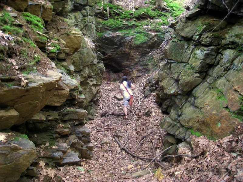

Why it's listed
Tantiusques Reservation is a graphite mine site in Sturbridge, Massachusetts, covering about 15 acres of wooded upland on both sides of Leadmine Road. Visible remains include an open cut about 750 feet long, a tunnel entrance, mounds and ramps of mine tailings, stone retaining walls, rock-cut steps and an old access road. English colonists first learned of the deposit in 1633 through Native informants, and John Winthrop, Jr. acquired it in 1643. The Winthrop family held it until 1784, with limited production, in part because early miners mistook graphite for lead. Frederick Tudor reopened the mine in 1828 to supply graphite for crucibles, and mining ended in the early 20th century. The site is considered the earliest documented lead or graphite mine in the region and, because it has been largely undisturbed since, it may reveal how mining methods developed over about three centuries. It has been held by a conservation trust since 1962.
Significance in brief: The nomination argues it is the earliest documented lead or graphite mine in the region and among the earliest in Massachusetts. It is tied to the Winthrop family from 1643 to 1784 and later to businessman Frederick Tudor. It is largely undisturbed and could yield information on mining technology over some 300 years, and the Native population likely used it earlier.
Machine-generated summary. This summary was generated by a language model from the official nomination document and has not been reviewed line by line by an editor. It may contain errors. Check the source document before relying on any detail. Source: nomination document (PDF) · National Archives catalog entry. NRHP reference 83004141, listed October 6, 1983. Summary generated October 2026 (model claude-sonnet-5-5, prompt v1.0-2026-10-29, confidence high).
Key facts
| Address | Leadmine Rd., Sturbridge |
|---|---|
| County | Worcester County |
| Listed | October 6, 1983 |
| Reference number | 83004141 |
| Resource type | Site |
| Criteria |
|
| Areas of significance | Industry, Exploration/Settlement |
| Level of significance | State, Local |
| Status (as stated in the nomination) | Described as excellently preserved and undisturbed since the early 20th century; owned by a conservation trust and open to the public. The interior mine shaft was not explored for safety reasons. |
| Acreage | 15 |
| Coordinates | 42.05814, -72.13038 (NPS GIS) |
What listing means for this property
Sites (archaeological sites, battlefields, landscapes) are often listed with a restricted address to protect them from looting or disturbance. Listing is honorary for private owners; federal undertakings on or near the site go through Section 106 review, and state laws may protect burials and artefacts regardless of listing.
General information, not legal or tax advice. Rules change; confirm with your State Historic Preservation Office or a qualified adviser.
Sources and further reading
- National Park Service, National Register of Historic Places database (snapshot May 2026), reference 83004141.
- Nomination form (PDF, National Archives) — catalog entry
- Wikipedia article (used for cross-checking only; text not reproduced here)
- Wikidata Q7683841
- This listing as JSON
Last updated October 2026. Found an error? See the editorial policy for how to report it.