Nix's Mate Daybeacon
Also known as: Nix's Mate channel marker or day marker

Why it's listed
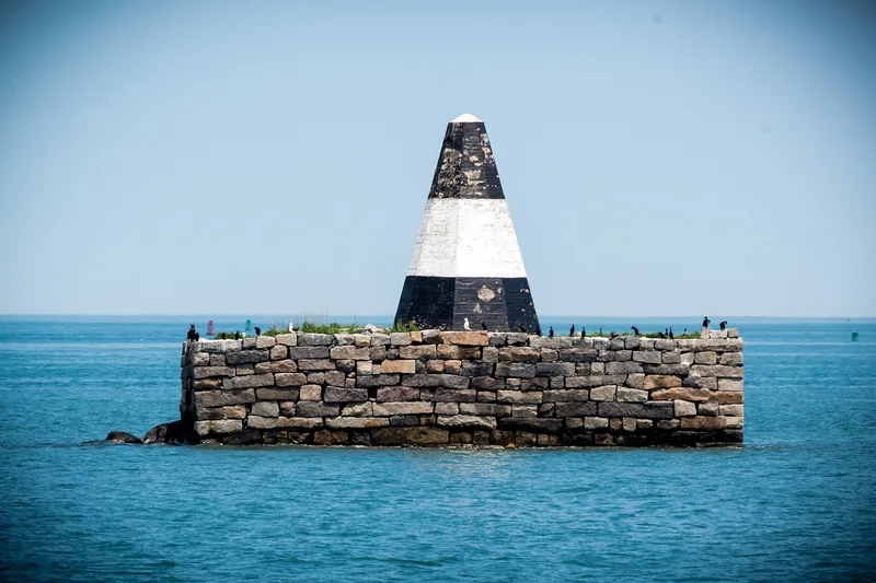
Nix's Mate Daybeacon marks a dangerous shoal near the convergence of three channels at the outer edge of Boston Harbor. It sits atop the remains of Nix's Mate, once a twelve-acre island and now a low rocky shoal. The marker has a rectangular granite base, about 67 by 32 feet and 16 feet high, topped by a truncated eight-sided wooden pyramid coated in concrete and painted black and white. Parts of the base date to work sponsored by Massachusetts in 1805 and the federal government in 1834. Lightning set the wooden pyramid on fire in 1841, and it was rebuilt. The Boston Marine Society pressed for such markers as government took over harbor navigation aids. The daybeacon was listed for its role in that effort and as a rare surviving permanent day marker. Erosion, storms and vandalism have left it listing about 20 degrees, with its base threatened.
Significance in brief: The nomination argues significance under Criterion A for its link to the development of navigational aids in Boston Harbor, led by the Boston Marine Society, the Commonwealth and later the federal government. Under Criterion C it is a rare surviving permanent, unlit day marker, with a distinctive form. It is also a well-known harbor landmark tied to the island's legends.
Machine-generated summary. This summary was generated by a language model from the official nomination document and has not been reviewed line by line by an editor. It may contain errors. Check the source document before relying on any detail. Source: nomination document (PDF) · National Archives catalog entry. NRHP reference 04000189, listed March 18, 2004. Summary generated October 2026 (model claude-sonnet-5-5, prompt v1.0-2026-10-29, confidence high).
Key facts
| Address | Nubble Channel, The Narrows, Boston Harbor, Boston |
|---|---|
| County | Suffolk County |
| Listed | March 18, 2004 |
| Reference number | 04000189 |
| Resource type | Structure |
| Period of significance | 1834-1952 |
| Criteria |
|
| Areas of significance | Maritime History |
| Level of significance | Local |
| Status (as stated in the nomination) | Deteriorating: the structure lists about 20 degrees due to erosion and loss of infill, the concrete is spalled and cracked, and vandals' fires have damaged the interior center column. It continues to serve as a navigation aid. |
| Acreage | 0.9 |
| Coordinates | 42.33231, -70.94441 (NPS GIS) |
What listing means for this property
National Register listing is honorary: it recognises significance and does not restrict what a private owner may do without federal money or permits. It unlocks the 20% federal rehabilitation tax credit for income-producing buildings, state credits in many states, and Section 106 review when federal agencies are involved. See what listing means in practice.
General information, not legal or tax advice. Rules change; confirm with your State Historic Preservation Office or a qualified adviser.
Sources and further reading
- National Park Service, National Register of Historic Places database (snapshot May 2026), reference 04000189.
- Nomination form (PDF, National Archives) — catalog entry
- Wikidata Q106475025
- This listing as JSON
Last updated October 2026. Found an error? See the editorial policy for how to report it.