Sachem Rock Farm

Why it's listed
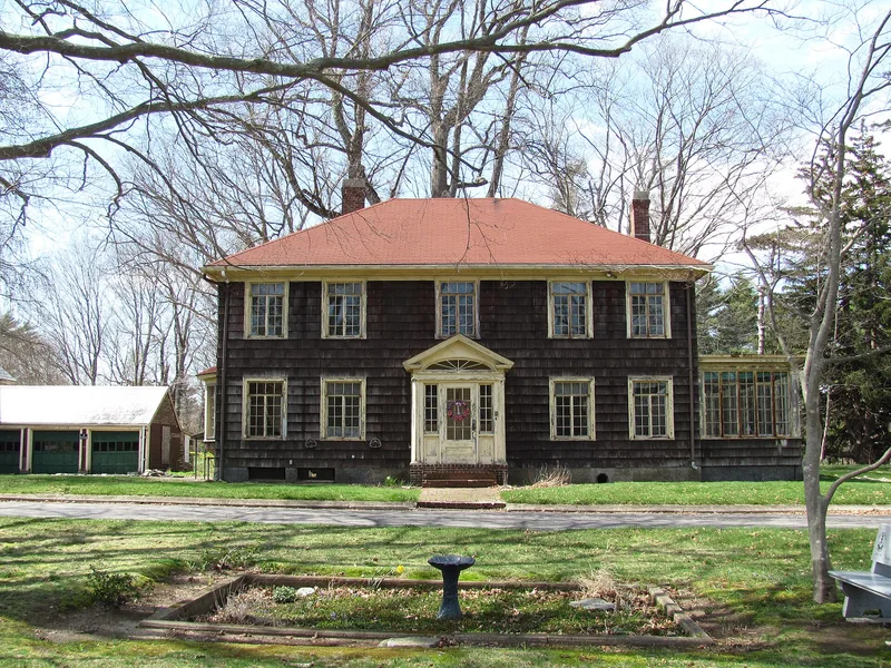
Sachem Rock Farm is a 31.63-acre farm at 355 Plymouth Street in East Bridgewater, Massachusetts, bordered on the west by a bend of the Satucket River. A long drive lined with old sugar maples leads to the farmstead, where a two-story Colonial Revival house built in 1927 stands on the fieldstone foundation of an 1869 farmhouse that burned the year before. Behind it is a barn complex begun in the 1870s for Thomas Hewitt, with a timber frame, a stanchion area with a manure trench, and later additions. Just west of the house rises Sachem Rock, a ledge about 25 feet high and over 70 feet long. Meadows, a stone-lined drainage ditch and early concrete garden features complete the landscape. The land traces back to the Latham family farms of the 1700s, later passing through owners such as Ezra Kingman. The farm is recognized for its continuous agricultural history and its intact farmstead and landscape.
Significance in brief: The nomination presents the property as a long-lived farmstead whose land descends from the Latham family farms of the 18th century. Its buildings and landscape show agricultural use through the 19th and early 20th centuries, and the large Sachem Rock ledge is a notable landmark. The form notes that the 1927 house replaced an 1869 farmhouse that burned in 1926.
Machine-generated summary. This summary was generated by a language model from the official nomination document and has not been reviewed line by line by an editor. It may contain errors. Check the source document before relying on any detail. Source: nomination document (PDF) · National Archives catalog entry. NRHP reference 06001129, listed December 11, 2006. Summary generated October 2026 (model claude-sonnet-5-5, prompt v1.0-2026-10-29, confidence medium).
Key facts
| Address | 355 Plymouth St., East Bridgewater |
|---|---|
| County | Plymouth County |
| Listed | December 11, 2006 |
| Reference number | 06001129 |
| Resource type | District |
| Architectural style | Colonial Revival |
| Areas of significance | Agriculture, Architecture, Community Planning and Development |
| Level of significance | Local |
| Status (as stated in the nomination) | Buildings are listed as vacant in the current functions; the land is open meadow mown for hay, and the garden club maintains plantings near the house. |
| Acreage | 31.6 |
| Coordinates | 42.01902, -70.95044 (NPS GIS) |
What listing means for this property
This is a historic district. Buildings within its boundary are either contributing (they add to the district's significance) or non-contributing. Owners of contributing income-producing buildings can claim the 20% federal rehabilitation tax credit; homeowners should look at state credits. National Register districts impose no design review by themselves; a local historic district ordinance, if one exists, does (the difference explained).
Noted as vacant in the nomination. Nomination documents can be decades old; current status may differ. If you are considering buying an empty listed property, read the due-diligence checklist.
General information, not legal or tax advice. Rules change; confirm with your State Historic Preservation Office or a qualified adviser.
Sources and further reading
- National Park Service, National Register of Historic Places database (snapshot May 2026), reference 06001129.
- Nomination form (PDF, National Archives) — catalog entry
- Wikipedia article (used for cross-checking only; text not reproduced here)
- Wikidata Q7396691
- This listing as JSON
Last updated October 2026. Found an error? See the editorial policy for how to report it.