Plymouth Light Station
Also known as: Gurner Light Station

Why it's listed
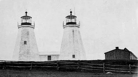
Plymouth (Gurnet) Light Station occupies Gurnet Point in Duxbury, Massachusetts, on the north side of the entrance to the harbors of Plymouth, Kingston and Duxbury. The Massachusetts Legislature established it in 1768 to guide ships into those ports, and the state ceded it to the federal government in 1790. Fire destroyed the lighthouse in 1801, a new light began operating in 1803, and exposure to the elements forced a rebuilding in 1843. The surviving tower is an octagonal, pyramidal wood-frame structure, 39 feet high and painted white. Other buildings include a brick oil house of about 1900, a brick fog signal building and a dwelling of 1960. During the Revolution a shot from the British frigate Niger pierced the lighthouse. In 1778 the brigantine General Arnold wrecked nearby, and seventy-two crew members froze to death. The twin lights continued until 1924, when the northeast tower was discontinued after 156 years.
Significance in brief: The station was established by the Massachusetts Legislature to guide shipping into three harbor towns. It figured in Revolutionary War events, including a stray shot from the frigate Niger that pierced the lighthouse, and in the 1778 loss of the brigantine General Arnold. It kept its twin lights for 156 years, until 1924, and its red sector covers the wreck-prone Mary Ann Rocks.
Machine-generated summary. This summary was generated by a language model from the official nomination document and has not been reviewed line by line by an editor. It may contain errors. Check the source document before relying on any detail. Source: nomination document (PDF) · National Archives catalog entry. NRHP reference 77000655, listed March 8, 1977. Summary generated October 2026 (model claude-sonnet-5-5, prompt v1.0-2026-10-29, confidence medium).
Key facts
| Address | SE of Duxbury at Gurnet Point, Duxbury |
|---|---|
| County | Plymouth County |
| Listed | March 8, 1977 |
| Reference number | 77000655 |
| Resource type | Structure |
| Areas of significance | Commerce, Military, Transportation, Maritime History |
| Level of significance | State |
| Status (as stated in the nomination) | Still an active Coast Guard light station in 1976. The tower is wood frame, built in 1843, and the station has a 1960 dwelling, a brick oil house and a fog signal building now used as a generator building. Condition is marked good. |
| Acreage | 0.9 |
| Coordinates | 42.00350, -70.60049 (NPS GIS) |
What listing means for this property
For a publicly owned building or structure, listing mainly matters when federal funds, permits or licences are involved: projects then go through Section 106 review so effects on the property are considered. Listing also strengthens applications for preservation grants and, for leased income-producing uses, can enable the federal rehabilitation tax credit.
General information, not legal or tax advice. Rules change; confirm with your State Historic Preservation Office or a qualified adviser.
Sources and further reading
- National Park Service, National Register of Historic Places database (snapshot May 2026), reference 77000655.
- Nomination form (PDF, National Archives) — catalog entry
- Wikipedia article (used for cross-checking only; text not reproduced here)
- Wikidata Q7205822
- This listing as JSON
Last updated October 2026. Found an error? See the editorial policy for how to report it.