Quincy Granite Railway
Also known as: Granite Railway
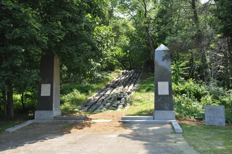

Why it's listed
A short stretch of early American railroad survives in Quincy, Massachusetts, north of the end of Bunker Hill Lane. The 250-foot section begins at the base of the defunct Bunker Hill Quarry and runs northeast along an embankment about four feet deep and five to six feet wide. Granite sleepers, each about seven feet long with hand-drilled holes for fastening rails, lie across the bed, though the rails themselves are gone. The line was built in 1826 to move granite for the Bunker Hill Monument, first by horse-drawn car to the Neponset River and then by barge. Engineer Gridley Bryant, backed financially by Thomas Handasyd Perkins, completed it in about seven months and perfected equipment such as the eight-wheeled car, turntable, derrick, switch and turnout. It is described as the first efficient commercial use of railways in the United States. This section was abandoned in the early 1830s when work shifted to another quarry.
Significance in brief: The railway was built to haul granite for the Bunker Hill Monument and is described as the first efficient commercial use of railways in the United States. Engineer Gridley Bryant developed key early railroad equipment during its construction, including the eight-wheeled car, turntable, portable derrick, switch and turnout. This section was used until the early 1830s, when operations moved to another quarry.
Machine-generated summary. This summary was generated by a language model from the official nomination document and has not been reviewed line by line by an editor. It may contain errors. Check the source document before relying on any detail. Source: nomination document (PDF) · National Archives catalog entry. NRHP reference 73000309, listed October 15, 1973. Summary generated October 2026 (model claude-sonnet-5-5, prompt v1.0-2026-10-29, confidence high).
Key facts
| Address | Bunker Hill Lane, Quincy |
|---|---|
| County | Norfolk County |
| Listed | October 15, 1973 |
| Reference number | 73000309 |
| Resource type | Structure |
| Period of significance | 19th Century (specific dates 1826, c. 1830) |
| Architect / builder | Gridley Bryant (engineer) |
| Areas of significance | Commerce, Engineering, Transportation, Invention |
| Level of significance | National |
| Status (as stated in the nomination) | Condition marked fair; the roadbed was abandoned in the early 1830s, no rails remain, and the property is listed as not in use. |
| Acreage | 0.7 |
| Coordinates | 42.23992, -71.03198 (NPS GIS) |
What listing means for this property
National Register listing is honorary: it recognises significance and does not restrict what a private owner may do without federal money or permits. It unlocks the 20% federal rehabilitation tax credit for income-producing buildings, state credits in many states, and Section 106 review when federal agencies are involved. See what listing means in practice.
Noted as vacant in the nomination. Nomination documents can be decades old; current status may differ. If you are considering buying an empty listed property, read the due-diligence checklist.
General information, not legal or tax advice. Rules change; confirm with your State Historic Preservation Office or a qualified adviser.
Sources and further reading
- National Park Service, National Register of Historic Places database (snapshot May 2026), reference 73000309.
- Nomination form (PDF, National Archives) — catalog entry
- Wikipedia article (used for cross-checking only; text not reproduced here)
- Wikidata Q287266
- This listing as JSON
Last updated October 2026. Found an error? See the editorial policy for how to report it.