Mount Wollaston Cemetery

Why it's listed
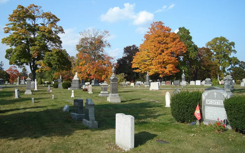
Mount Wollaston Cemetery is a 51-acre municipal burial ground on a low hill in Quincy's Merrymount area, laid out in 1855 when the older Hancock Cemetery was filling. A town committee modelled it on the rural garden cemetery type, with curving tree-lined roads and generous family plots. A low granite wall with pyramid-capped posts encloses the grounds; the present wall was built by the Works Progress Administration between 1935 and 1940. Inside are an estimated 85,000 to 115,000 gravestones and markers, a granite office building, a row of mausolea, and war memorials including a Civil War monument of 1868 and a firemen's memorial of 1929. The cemetery was listed for its place in Quincy's history as the second public burial ground and for its ties to the local granite industry, shown in carved monuments, polished stones and large turned granite balls. It also reflects the garden cemetery movement in its design and artistry.
Significance in brief: The cemetery is significant locally under Criterion A for its role as Quincy's second public burial ground and for its link to the Quincy granite industry. Under Criterion C, it is an excellent example of the rural or garden cemetery movement, with many finely carved granite gravestones, mausolea and monuments, including examples of granite 'turning'. A WPA-built granite wall from 1935-1940 is a notable later feature.
Machine-generated summary. This summary was generated by a language model from the official nomination document and has not been reviewed line by line by an editor. It may contain errors. Check the source document before relying on any detail. Source: nomination document (PDF) · National Archives catalog entry. NRHP reference 94000035, listed February 18, 1994. Summary generated October 2026 (model claude-sonnet-5-5, prompt v1.0-2026-10-29, confidence high).
Key facts
| Address | 20 Sea St., Quincy |
|---|---|
| County | Norfolk County |
| Listed | February 18, 1994 |
| Reference number | 94000035 |
| Resource type | District |
| Period of significance | 1855-1943 |
| Architect / builder | Briggs Luther, Surveyor (1855); Daniel Briggs, Cemetery Planner (1855); also Luke Rideout, Charles R. Mitchell, Chester Mitchell, Florence McAuliffe, Bruce Wilder Saville, A. J. Cipollini for individual features |
| Criteria |
|
| Areas of significance | Social History, Landscape Architecture, Community Planning and Development, Architecture, Art |
| Level of significance | Local |
| Status (as stated in the nomination) | Active, well-maintained cemetery to the present, with additional burials continually added; the granite walls were rebuilt and restored in 1977. |
| Acreage | 52 |
| Coordinates | 42.25847, -70.99892 (NPS GIS) |
What listing means for this property
This is a historic district. Buildings within its boundary are either contributing (they add to the district's significance) or non-contributing. Owners of contributing income-producing buildings can claim the 20% federal rehabilitation tax credit; homeowners should look at state credits. National Register districts impose no design review by themselves; a local historic district ordinance, if one exists, does (the difference explained).
General information, not legal or tax advice. Rules change; confirm with your State Historic Preservation Office or a qualified adviser.
Sources and further reading
- National Park Service, National Register of Historic Places database (snapshot May 2026), reference 94000035.
- Nomination form (PDF, National Archives) — catalog entry
- Wikipedia article (used for cross-checking only; text not reproduced here)
- Wikidata Q14715732
- This listing as JSON
Last updated October 2026. Found an error? See the editorial policy for how to report it.