Brant Point Light Station

Why it's listed
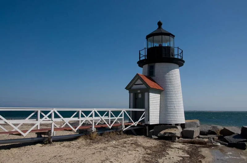
Brant Point Light Station occupies a sandy spit at the western side of the entrance to Nantucket Harbor. Its principal feature is the active 1901 tower, a white shingled cylinder about 26 feet tall, reached by a long elevated wooden walkway over the beach. Inside, the tower keeps a modernized Fresnel lens, a ten-sided lens room and an iron balcony with a simple original-looking railing. Nearby are an 1856-57 brick keeper's house with an attached, now dismantled tower, and an oil house, all counted as contributing parts of the complex. Lighthouses have stood at this point since a 1746 town vote, though earlier towers burned or blew down, and the 1795 cession to the United States involved the sixth light. The 1854 rebuilding used one of the first Fresnel lenses in the country. The station is valued for its integrity and its role in the history of navigation aids in Massachusetts, and for marking the first structure seen on approaching Nantucket.
Significance in brief: The nomination argues that the station keeps integrity of location, design, materials and workmanship and reflects the development of aids to navigation in Massachusetts. Although none of its 18th century lights survive, it still marks an important navigational point within the Nantucket National Landmark District. It is stated to meet criteria A and C.
Machine-generated summary. This summary was generated by a language model from the official nomination document and has not been reviewed line by line by an editor. It may contain errors. Check the source document before relying on any detail. Source: nomination document (PDF) · National Archives catalog entry. NRHP reference 87002029, listed September 28, 1987. Summary generated October 2026 (model claude-sonnet-5-5, prompt v1.0-2026-10-29, confidence medium).
Key facts
| Address | Brant Pt., Nantucket |
|---|---|
| County | Nantucket County |
| Listed | September 28, 1987 |
| Reference number | 87002029 |
| Resource type | Structure |
| Criteria |
|
| Areas of significance | Engineering, Transportation, Architecture, Maritime History |
| Level of significance | National, State, Local |
| Status (as stated in the nomination) | Listed as unmanned and active; the 1901 tower is active, while the 1856-57 tower is dismantled and abandoned, with the Coast Guard planning to convert it to a communications and watchstanders room. |
| Acreage | 3.2 |
| Within district | Nantucket Historic District |
| Coordinates | 41.28910, -70.09218 (NPS GIS) |
What listing means for this property
For a publicly owned building or structure, listing mainly matters when federal funds, permits or licences are involved: projects then go through Section 106 review so effects on the property are considered. Listing also strengthens applications for preservation grants and, for leased income-producing uses, can enable the federal rehabilitation tax credit.
General information, not legal or tax advice. Rules change; confirm with your State Historic Preservation Office or a qualified adviser.
Sources and further reading
- National Park Service, National Register of Historic Places database (snapshot May 2026), reference 87002029.
- Nomination form (PDF, National Archives) — catalog entry
- Wikipedia article (used for cross-checking only; text not reproduced here)
- Wikidata Q4957614
- This listing as JSON
Last updated October 2026. Found an error? See the editorial policy for how to report it.