Mystic Gatehouse

Why it's listed
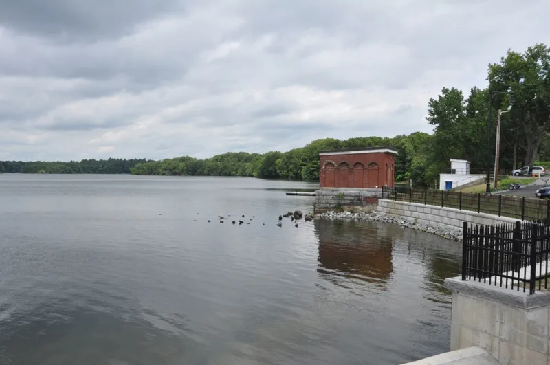
Beside Upper Mystic Lake in Winchester, Massachusetts, a small brick gatehouse recalls the water supply built for the City of Charlestown. Constructed between 1862 and 1865 as part of the Mystic Water Works, it is a one-story rectangular building set on a granite gate chamber. Each side has false arches topped by fanlights, now bricked up, and a flat roof has replaced the original bracketed, hipped roof. Water was pumped from the lakes to a reservoir on what is now the Tufts University campus. Boston took over the system when Charlestown was annexed in 1874, and the Metropolitan Water Board assumed operations in 1898, though the supply was never used because of poor water quality. The system is now out of service and has lost integrity as a whole, but the gatehouse, the adjacent dam and the pumping station remain good examples of their types. It was listed for its association with the works and as a representative mid-nineteenth century water supply structure.
Significance in brief: It is associated with the Mystic Water Works system and represents the small, integrated municipal water supply systems of the mid-nineteenth century. Although the system as a whole has lost integrity, the gatehouse retains integrity of location, setting, materials, workmanship and feeling. Criteria A and C were confirmed as applicable in the listing record.
Machine-generated summary. This summary was generated by a language model from the official nomination document and has not been reviewed line by line by an editor. It may contain errors. Check the source document before relying on any detail. Source: nomination document (PDF) · National Archives catalog entry. NRHP reference 89002284, listed January 18, 1990. Summary generated October 2026 (model claude-sonnet-5-5, prompt v1.0-2026-10-29, confidence medium).
Key facts
| Address | E of Edgewater Pl. on SE end of Upper Mystic Lake, Winchester |
|---|---|
| County | Middlesex County |
| Listed | January 18, 1990 |
| Reference number | 89002284 |
| Resource type | Structure |
| Period of significance | 1862-1865 |
| Criteria |
|
| Areas of significance | Community Planning and Development, Engineering, Politics/Government, Architecture |
| Level of significance | State, Local |
| Status (as stated in the nomination) | Condition fair; no longer in service. Window arches were bricked up in the 20th century and the original roof was replaced with a flat roof. |
| Acreage | 0.5 |
| Coordinates | 42.43126, -71.14719 (NPS GIS) |
What listing means for this property
National Register listing is honorary: it recognises significance and does not restrict what a private owner may do without federal money or permits. It unlocks the 20% federal rehabilitation tax credit for income-producing buildings, state credits in many states, and Section 106 review when federal agencies are involved. See what listing means in practice.
General information, not legal or tax advice. Rules change; confirm with your State Historic Preservation Office or a qualified adviser.
Sources and further reading
- National Park Service, National Register of Historic Places database (snapshot May 2026), reference 89002284.
- Nomination form (PDF, National Archives) — catalog entry
- Wikipedia article (used for cross-checking only; text not reproduced here)
- Wikidata Q6948942
- This listing as JSON
Last updated October 2026. Found an error? See the editorial policy for how to report it.