Coleman Bridge

Why it's listed
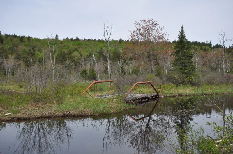
Coleman Bridge carries an abandoned stretch of Windsor Bush Road over Phelps Brook in the woods of Windsor State Forest, Berkshire County, Massachusetts. Built about 1894, the 31-foot span is a pony truss made with iron pipe top chords, a design patented in 1893 by local machinist and entrepreneur Charles H. Ball. Ball aimed to offer farm towns an iron bridge that cost little more than a wooden one, and he avoided riveting to save labor. The bridge is the last intact example of his design in Massachusetts, since two others were dismantled and put into storage. It keeps nearly all of its original materials, though the wood stringers and plank deck were replaced and the log abutments were rebuilt in concrete. The farming community of Windsor Bush that it once served has largely disappeared, and the crossing is now a trail. It was listed for its engineering and transportation importance and for its link to Ball's work.
Significance in brief: It is the last intact example in Massachusetts of the pipe truss bridge patented by Windsor machinist Charles H. Ball. Its iron pipe top chords and sparing use of rods set it apart from other iron truss types of the period. It retains nearly all of its original materials and design features and sits in its original location. It is considered significant at the local level under criteria A and C.
Machine-generated summary. This summary was generated by a language model from the official nomination document and has not been reviewed line by line by an editor. It may contain errors. Check the source document before relying on any detail. Source: nomination document (PDF) · National Archives catalog entry. NRHP reference 00000112, listed February 18, 2000. Summary generated October 2026 (model claude-sonnet-5-5, prompt v1.0-2026-10-29, confidence high).
Key facts
| Address | Windsor Bush Rd. over Phelps Brook, Windosor |
|---|---|
| County | Berkshire County |
| Listed | February 18, 2000 |
| Reference number | 00000112 |
| Resource type | Structure |
| Period of significance | c1894-1949 |
| Architect / builder | Charles H. Ball, designer and patentee |
| Architectural style | No style |
| Criteria |
|
| Areas of significance | Engineering, Transportation |
| Level of significance | Local |
| Status (as stated in the nomination) | Located on an abandoned section of road and used today as a recreational trail in a protected wilderness area. The deck and stringers have been replaced, and the abutments were rebuilt in concrete. |
| Acreage | 0.9 |
| Coordinates | 42.53242, -72.99291 (NPS GIS) |
What listing means for this property
For a publicly owned building or structure, listing mainly matters when federal funds, permits or licences are involved: projects then go through Section 106 review so effects on the property are considered. Listing also strengthens applications for preservation grants and, for leased income-producing uses, can enable the federal rehabilitation tax credit.
General information, not legal or tax advice. Rules change; confirm with your State Historic Preservation Office or a qualified adviser.
Sources and further reading
- National Park Service, National Register of Historic Places database (snapshot May 2026), reference 00000112.
- Nomination form (PDF, National Archives) — catalog entry
- Wikipedia article (used for cross-checking only; text not reproduced here)
- Wikidata Q5142985
- This listing as JSON
Last updated October 2026. Found an error? See the editorial policy for how to report it.