McGovney-Yunker Farmstead
Also known as: Yunker Farm

Why it's listed
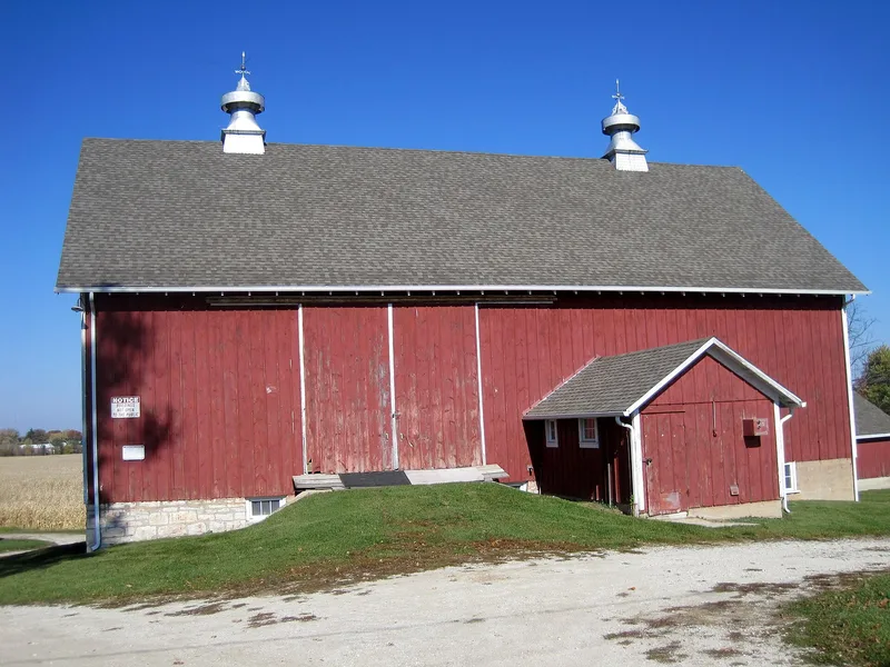
This farmstead on LaPorte Road in Mokena, Illinois, preserves the layout of a working farm that grew over more than a century. John McGovney, the first permanent non-native resident of Frankfort Township, squatted on the land and obtained it from the federal government in 1841. His youngest son, Elijah, expanded the farm and built much of its early structure. The surviving complex includes a T-plan farmhouse from about 1860, a gable bank barn, a well house, a smokehouse/woodshed, a chicken coop, a brooder house, and later cattle, hog and corn-storage buildings from the 1940s and 1950s. The house was modernized in the early twentieth century with Arts and Crafts details and remodeled again in the 1960s and 1970s. Buildings cluster around a farmyard, and LaPorte Road divides the original 116 acres. The property was recognized for its link to agricultural development in rural Will County, with a period of significance from 1841 to 1956. It is listed as a district with nine contributing buildings and structures plus several noncontributing ones.
Significance in brief: The farmstead reflects the nineteenth and twentieth century agricultural development of rural Will County. It is described as the first parcel settled in Mokena and one of few farms there not redeveloped. The wooded land south of the road is a remnant of McGovney wood lots and frames a historic view.
Machine-generated summary. This summary was generated by a language model from the official nomination document and has not been reviewed line by line by an editor. It may contain errors. Check the source document before relying on any detail. Source: nomination document (PDF) · National Archives catalog entry. NRHP reference 06000448, listed May 31, 2006. Summary generated October 2026 (model claude-sonnet-5-5, prompt v1.0-2026-10-29, confidence medium).
Key facts
| Address | 10824 LaPorte Rd., Mokena |
|---|---|
| County | Will County |
| Listed | May 31, 2006 |
| Reference number | 06000448 |
| Resource type | District |
| Period of significance | 1841-1956 |
| Architectural style | Other: T-Plan |
| Criteria |
|
| Areas of significance | Agriculture |
| Level of significance | Local |
| Status (as stated in the nomination) | Current function is listed as vacant/not in use and work in progress; the form also says the farm is still being tilled. |
| Acreage | 30 |
| Coordinates | 41.52536, -87.88012 (NPS GIS) |
What listing means for this property
This is a historic district. Buildings within its boundary are either contributing (they add to the district's significance) or non-contributing. Owners of contributing income-producing buildings can claim the 20% federal rehabilitation tax credit; homeowners should look at state credits. National Register districts impose no design review by themselves; a local historic district ordinance, if one exists, does (the difference explained).
Noted as vacant in the nomination. Nomination documents can be decades old; current status may differ. If you are considering buying an empty listed property, read the due-diligence checklist.
General information, not legal or tax advice. Rules change; confirm with your State Historic Preservation Office or a qualified adviser.
Sources and further reading
- National Park Service, National Register of Historic Places database (snapshot May 2026), reference 06000448.
- Nomination form (PDF, National Archives) — catalog entry
- Wikipedia article (used for cross-checking only; text not reproduced here)
- Wikidata Q6801401
- This listing as JSON
Last updated October 2026. Found an error? See the editorial policy for how to report it.