Fulton Commercial Historic District

Why it's listed
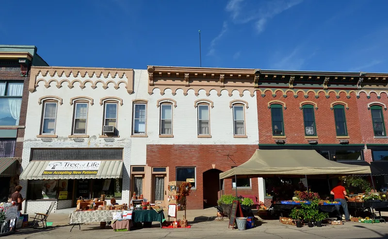
Fulton's commercial core runs along 4th Street from 9th to 12th Avenues, close to the Mississippi River in northwest Illinois. The district covers about 6.4 acres and holds 33 contributing resources, including attached brick commercial blocks, a 1930s post office, a 1956 fire station, a 1927 war memorial and a World War II carriage gun. The earliest buildings date from 1856, and the Utz Block of 1870 is among the older examples. Most pre-1900 buildings are Italianate, built of locally made brick, with later Commercial Style and Classical Revival buildings mixed in. The district grew from the traffic of ferries, railroads, the 1891 Lyons-Fulton High Bridge and later the Lincoln Highway, which ran down 4th Street until the 1970s. Storefronts housed groceries, department stores and restaurants, supported by local manufacturing and freight handling. The district was listed for its role as the town's commercial and social center and for its architecture, which retains original massing and many character-defining features despite altered storefronts.
Significance in brief: The nomination argues the district was the commercial and social center of Fulton from 1856 through 1956, shaped by river, rail, bridge and highway traffic. It is also significant under Criterion C for its architecture, mostly locally made brick Italianate buildings mixed with Commercial Style, Classical Revival and some Modern Movement influence.
Machine-generated summary. This summary was generated by a language model from the official nomination document and has not been reviewed line by line by an editor. It may contain errors. Check the source document before relying on any detail. Source: nomination document (PDF) · National Archives catalog entry. NRHP reference 12000062, listed March 7, 2012. Summary generated October 2026 (model claude-sonnet-5-5, prompt v1.0-2026-10-29, confidence medium).
Key facts
| Address | 4th St. between 10th & 12th Aves., Fulton |
|---|---|
| County | Whiteside County |
| Listed | March 7, 2012 |
| Reference number | 12000062 |
| Resource type | District |
| Period of significance | 1856-1956 |
| Architect / builder | Gottlieb Utz (Utz Block) |
| Architectural style | Late Victorian: Italianate; Late 19th/Early 20th Century: Commercial Style; Late 19th/Early 20th Century Revivals: Classical Revival; Modern Movement |
| Criteria |
|
| Areas of significance | Commerce, Architecture |
| Level of significance | Local |
| Status (as stated in the nomination) | Buildings are described as generally in good condition and retaining adequate integrity, though many storefronts and upper-floor windows have been replaced. |
| Acreage | 6.4 |
| Coordinates | 41.86806, -90.16582 (NPS GIS) |
What listing means for this property
This is a historic district. Buildings within its boundary are either contributing (they add to the district's significance) or non-contributing. Owners of contributing income-producing buildings can claim the 20% federal rehabilitation tax credit; homeowners should look at state credits. National Register districts impose no design review by themselves; a local historic district ordinance, if one exists, does (the difference explained).
General information, not legal or tax advice. Rules change; confirm with your State Historic Preservation Office or a qualified adviser.
Sources and further reading
- National Park Service, National Register of Historic Places database (snapshot May 2026), reference 12000062.
- Nomination form (PDF, National Archives) — catalog entry
- Wikipedia article (used for cross-checking only; text not reproduced here)
- Wikidata Q28153462
- This listing as JSON
Last updated October 2026. Found an error? See the editorial policy for how to report it.