Cahokia Mounds
Also known as: Monks Mounds

Why it's listed
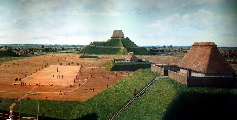
Cahokia Mounds is a vast Mississippian-era site east of St. Louis, in the flood plain known as the American Bottoms. Its centerpiece, Monks Mound, covers about 15 acres and rises in four terraces to roughly 100 feet. More than one hundred smaller mounds served as platforms for temples and residences, as burial places, or as markers of the city's limits. The settlement followed a regular north-south and east-west plan, included houses grouped around plazas, and was ringed in its core by a log palisade. Circles of posts called woodhenges are interpreted as calendars. Occupied from about 800 to 1500 A.D., the city may have held 40,000 people around 1150 and acted as a major trading hub, with goods arriving from the Ozarks, Lake Superior, the Gulf Coast and beyond. The nomination treats it as unique and important for understanding early urban life in North America. Part of the site is now a state park, though roads, an interstate and development have intruded on the remainder.
Significance in brief: The form describes Cahokia as the largest Mississippian Period community in eastern North America, with a planned rectangular layout, a timber palisade and woodhenges. It may have housed 40,000 people at its peak and served as a major trade center. It is called of preeminent importance for studying prehistoric urbanism.
Machine-generated summary. This summary was generated by a language model from the official nomination document and has not been reviewed line by line by an editor. It may contain errors. Check the source document before relying on any detail. Source: nomination document (PDF) · National Archives catalog entry. NRHP reference 66000899, listed October 15, 1966. Summary generated October 2026 (model claude-sonnet-5-5, prompt v1.0-2026-10-29, confidence high).
Key facts
| Address | 7850 Collinsville Rd., Cahokia Mounds State Park, Collinsville |
|---|---|
| County | St. Clair County |
| Listed | October 15, 1966 |
| Reference number | 66000899 |
| Resource type | Site |
| Period of significance | approximately 800-1500 A.D. |
| Areas of significance | Prehistoric |
| Level of significance | National |
| National Historic Landmark | Yes, designated July 19, 1964 |
| Status (as stated in the nomination) | About 650 of roughly 4,000 acres are state-owned and maintained as a park with a museum and a reconstructed section of palisade. Other mounds are privately owned, and some have been nearly obliterated by cultivation or urban expansion. |
| Acreage | 4000 |
| Coordinates | 38.65991, -90.07976 (NPS GIS) |
What listing means for this property
Sites (archaeological sites, battlefields, landscapes) are often listed with a restricted address to protect them from looting or disturbance. Listing is honorary for private owners; federal undertakings on or near the site go through Section 106 review, and state laws may protect burials and artefacts regardless of listing.
General information, not legal or tax advice. Rules change; confirm with your State Historic Preservation Office or a qualified adviser.
Sources and further reading
- National Park Service, National Register of Historic Places database (snapshot May 2026), reference 66000899.
- Nomination form (PDF, National Archives) — catalog entry
- Wikipedia article (used for cross-checking only; text not reproduced here)
- Wikidata Q333661
- This listing as JSON
Last updated October 2026. Found an error? See the editorial policy for how to report it.