Fort Massac Site
Also known as: Fort Massiac

Why it's listed
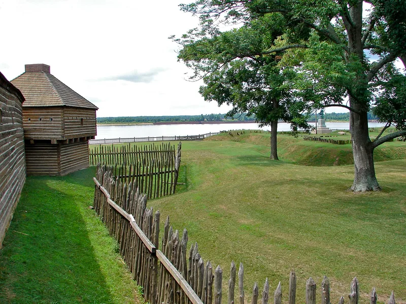
Overlooking the Ohio River from a bluff about fifty feet above the water, this site in Fort Massac State Park near Metropolis, Illinois, contains the remains of three forts built in succession. The French erected Fort Ascension in 1757 to protect supply routes, then rebuilt it in 1760 as Fort Massiac. In 1794 the United States fortified the ruins with four blockhouses, a ditch and a stockade, naming it Fort Massac. The American post, occupied until 1814, served as a port of entry and customs collection point, hosted a post office, and was the staging area for volunteers in the War of 1812. George Rogers Clark landed nearby in 1778, and figures such as Zebulon Pike, James Wilkinson and Aaron Burr are tied to its history. Settlers drawn to the fort founded the community that became Metropolis. Archaeological work began in 1939, and a ground outline now marks the French fort.
Significance in brief: The site holds the remains of French and American frontier forts that guarded the lower Ohio River. The American Fort Massac (1794-1814) is judged the most important, serving as a customs port of entry, post office, military headquarters and staging area. Settlements around it grew into Metropolis.
Machine-generated summary. This summary was generated by a language model from the official nomination document and has not been reviewed line by line by an editor. It may contain errors. Check the source document before relying on any detail. Source: nomination document (PDF) · National Archives catalog entry. NRHP reference 71000293, listed July 14, 1971. Summary generated October 2026 (model claude-sonnet-5-5, prompt v1.0-2026-10-29, confidence medium).
Key facts
| Address | SE of Metropolis on the Ohio River, Metropolis |
|---|---|
| County | Massac County |
| Listed | July 14, 1971 |
| Reference number | 71000293 |
| Resource type | Site |
| Period of significance | 1756-1815 |
| Architect / builder | Fort Ascension built by the French under Captain Charles Philippe Aubry (1757); American fort built under Captain Thomas Doyle (1794); site excavated by Paul Maynard (1939) |
| Areas of significance | Commerce, Military, Politics/Government |
| Level of significance | National |
| Status (as stated in the nomination) | Ruins, altered; state park open to the public, with a ground outline of the French fort, reconstructed ditch, flagpoles and a George Rogers Clark statue. |
| Acreage | 322 |
| Coordinates | 37.14658, -88.70895 (NPS GIS) |
What listing means for this property
Sites (archaeological sites, battlefields, landscapes) are often listed with a restricted address to protect them from looting or disturbance. Listing is honorary for private owners; federal undertakings on or near the site go through Section 106 review, and state laws may protect burials and artefacts regardless of listing.
General information, not legal or tax advice. Rules change; confirm with your State Historic Preservation Office or a qualified adviser.
Sources and further reading
- National Park Service, National Register of Historic Places database (snapshot May 2026), reference 71000293.
- Nomination form (PDF, National Archives) — catalog entry
- Wikipedia article (used for cross-checking only; text not reproduced here)
- Wikidata Q3077937
- This listing as JSON
Last updated October 2026. Found an error? See the editorial policy for how to report it.