Galena Historic District

Why it's listed
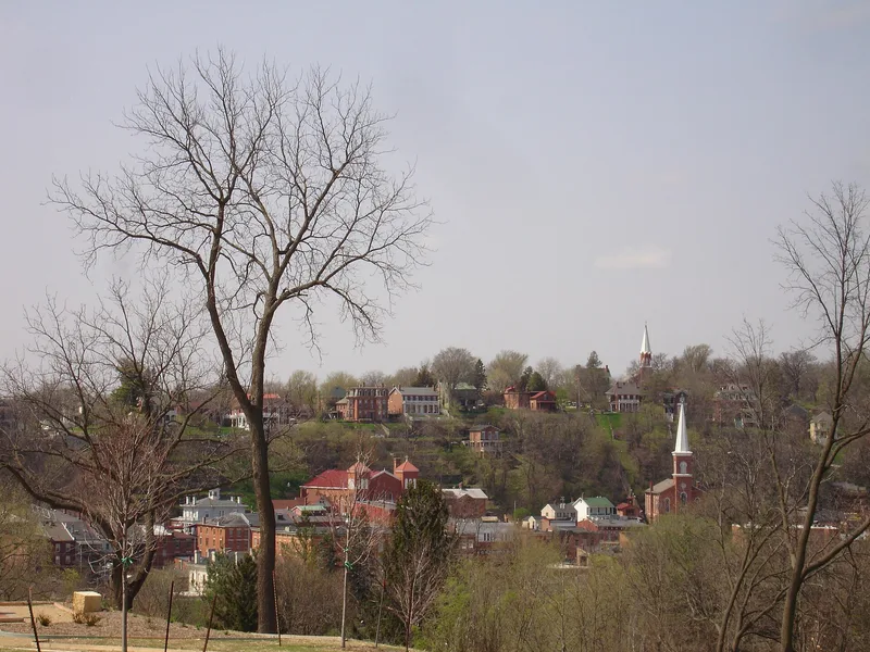
Galena's historic district takes in more than ninety percent of the Illinois city, about 950 acres and roughly one thousand buildings erected before 1900. It is the older part of a living town, mixing shops, public buildings, industry and homes. Buildings rise in three terraces above the Galena River: Main Street for commerce, Bench Street for public buildings and church steeples, and Prospect Street for housing. Of about 150 buildings along Main Street, only ten date from after 1900. Styles run from simple 1820s country buildings through Greek Revival to Victorian, built mainly of buff limestone, local red-orange brick, wood and cast iron. The city was named for lead ore and grew rich from mining and steamboat trade, becoming the wealthiest in Illinois by the 1840s. Railroads and falling lead prices ended that prosperity after the 1860s. Galena sent nine generals to the Union Army, including Ulysses S. Grant, and since 1965 a preservation ordinance has regulated changes within the district.
Significance in brief: Galena grew wealthy from lead mining and Mississippi River trade, becoming the wealthiest city in Illinois by the 1840s. The district preserves a remarkably intact mid-19th-century townscape of terraced streets and consistent commercial architecture. It is also tied to Ulysses S. Grant, who lived and clerked in Galena before and after the Civil War.
Machine-generated summary. This summary was generated by a language model from the official nomination document and has not been reviewed line by line by an editor. It may contain errors. Check the source document before relying on any detail. Source: nomination document (PDF) · National Archives catalog entry. NRHP reference 69000056, listed October 18, 1969. Summary generated October 2026 (model claude-sonnet-5-5, prompt v1.0-2026-10-29, confidence medium).
Key facts
| Address | Galena and environs, Galena |
|---|---|
| County | Jo Daviess County |
| Listed | October 18, 1969 |
| Reference number | 69000056 |
| Resource type | District |
| Period of significance | 19th Century |
| Architectural style | Mixed styles, from simple country architecture of the 1820s-1830s through Greek Revival and later Victorian |
| Areas of significance | Industry, Community Planning and Development, Commerce, Military, Transportation, Politics/Government |
| Level of significance | Local |
| Status (as stated in the nomination) | Described as the older section of a living city, occupied and in use; condition marked good, with a 1965 preservation ordinance regulating new construction and exterior alterations. |
| Coordinates | 42.41860, -90.42787 (NPS GIS) |
What listing means for this property
This is a historic district. Buildings within its boundary are either contributing (they add to the district's significance) or non-contributing. Owners of contributing income-producing buildings can claim the 20% federal rehabilitation tax credit; homeowners should look at state credits. National Register districts impose no design review by themselves; a local historic district ordinance, if one exists, does (the difference explained).
General information, not legal or tax advice. Rules change; confirm with your State Historic Preservation Office or a qualified adviser.
Sources and further reading
- National Park Service, National Register of Historic Places database (snapshot May 2026), reference 69000056.
- Nomination form (PDF, National Archives) — catalog entry
- Wikipedia article (used for cross-checking only; text not reproduced here)
- Wikidata Q5518384
- This listing as JSON
Last updated October 2026. Found an error? See the editorial policy for how to report it.