Cairo Historic District
Also known as: See also:Magnolia Manor; Old Customhouse

Why it's listed
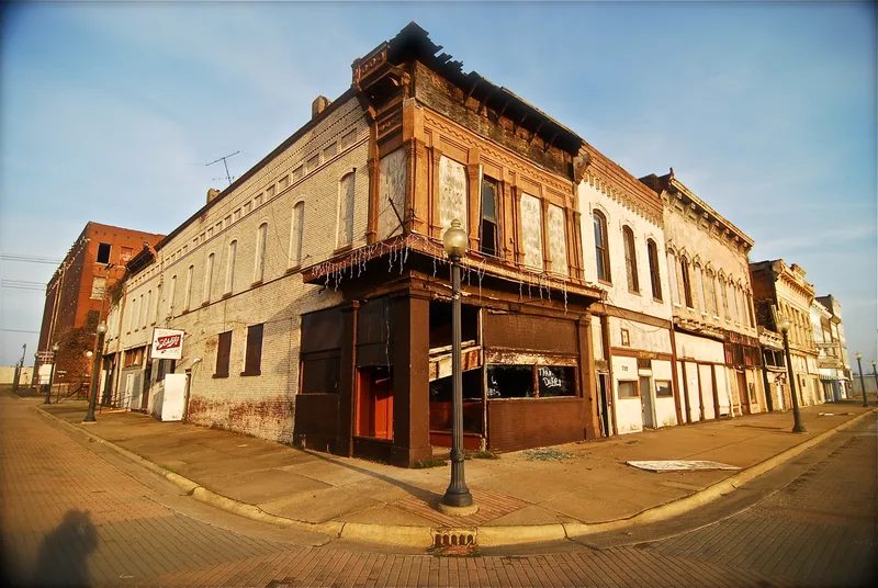
Cairo Historic District takes in most of the built-up city at the southern tip of Illinois, where the Ohio and Mississippi Rivers meet. The city sits on a narrow peninsula enclosed by levees. Of roughly 980 structures, 207 were judged architecturally or historically significant. Italianate houses are the most common style, joined by ornate cast-iron and galvanized-iron commercial fronts along Commercial Avenue and 8th Street, small Queen Anne and Classic cottages, and a few notable Romanesque buildings. The district matters because it records Cairo's story: repeated attempts to found a city at the river junction, the Illinois Central Railroad's southern terminus, Civil War activity tied to General Grant, and later prominence as a shipping center. The nomination values the overall townscape over single landmarks. It also warns that population loss since 1940 has left many vacant lots and decaying buildings, especially in the lower town, which threatens that historic character.
Significance in brief: The nomination argues Cairo's streets and buildings record its unusual history: three attempts to found a city at the river junction, its role as the southern terminus of the Illinois Central Railroad, its Civil War importance, and its rise as a river shipping center. The whole urban fabric, from Italianate mansions to workers' cottages and iron-fronted commercial blocks, is valued more than any individual building. The form also stresses that decay and vacancy threaten that character.
Machine-generated summary. This summary was generated by a language model from the official nomination document and has not been reviewed line by line by an editor. It may contain errors. Check the source document before relying on any detail. Source: nomination document (PDF) · National Archives catalog entry. NRHP reference 79000815, listed January 26, 1979. Summary generated October 2026 (model claude-sonnet-5-5, prompt v1.0-2026-10-29, confidence medium).
Key facts
| Address | Roughly bounded by Park, 33rd, Sycamore, 21st, Cedar, and 4th Sts., and the Ohio River, Cairo |
|---|---|
| County | Alexander County |
| Listed | January 26, 1979 |
| Reference number | 79000815 |
| Resource type | District |
| Period of significance | 1800-1899 and 1900- |
| Architectural style | Predominantly Italianate, with ornate post-Civil War storefronts, Queen Anne and Classic cottages, Romanesque, Gothic, Classic Revival and a few Art Moderne and bungalow examples |
| Areas of significance | Military, Transportation, Exploration/Settlement, Politics/Government, Architecture |
| Level of significance | National |
| Status (as stated in the nomination) | Condition is marked excellent and deteriorated. Many properties in the lower town are vacant or in poor repair, and about 68 structures are intrusions. |
| Acreage | 0.3 |
| Coordinates | 37.00743, -89.17716 (NPS GIS) |
What listing means for this property
This is a historic district. Buildings within its boundary are either contributing (they add to the district's significance) or non-contributing. Owners of contributing income-producing buildings can claim the 20% federal rehabilitation tax credit; homeowners should look at state credits. National Register districts impose no design review by themselves; a local historic district ordinance, if one exists, does (the difference explained).
General information, not legal or tax advice. Rules change; confirm with your State Historic Preservation Office or a qualified adviser.
Sources and further reading
- National Park Service, National Register of Historic Places database (snapshot May 2026), reference 79000815.
- Nomination form (PDF, National Archives) — catalog entry
- Wikipedia article (used for cross-checking only; text not reproduced here)
- Wikidata Q16825212
- This listing as JSON
Last updated October 2026. Found an error? See the editorial policy for how to report it.