Philomath Historic District

Why it's listed
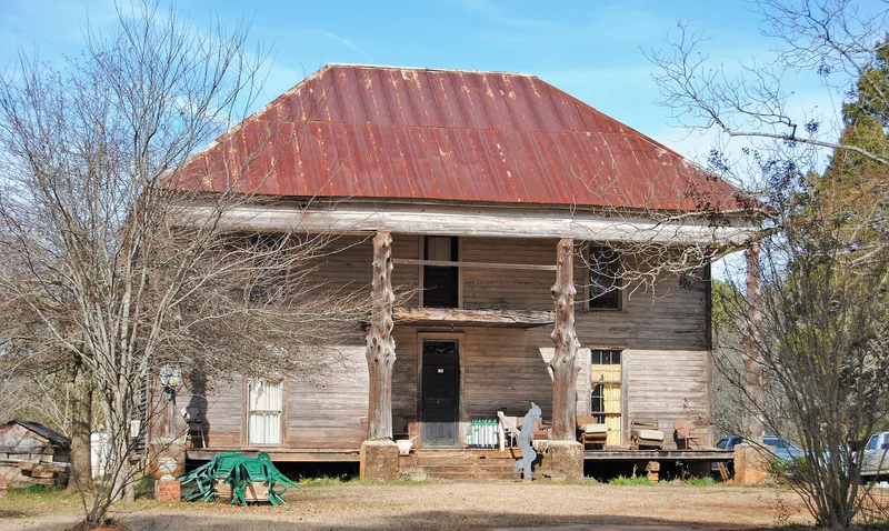
Philomath is a small Oglethorpe County, Georgia, community strung along State Route 22, and its historic district takes in about 311 acres. A one-mile stretch of mostly nineteenth-century homes, a small commercial area and a white frame Presbyterian church built around 1900 sit alongside pastures, forest, a section of the Bartram Trail and the Bartram Buffalo Lick. Three Greek Revival houses stand out, among them the Globe, considered the finest in the county, and the nearly identical Glenn-Callaway House. Older Plantation Plain houses and a log cabin dated about 1780 add to the mix. The lick, a clay area visited by naturalist William Bartram, served as an Indian meeting place and was named in the 1773 Treaty of Augusta. The town was also home to the Reid Academy, a boys' boarding school, and was where Confederate cabinet members held their last council of war in 1865. The settlement pattern appears largely original.
Significance in brief: The nomination argues the district is important architecturally, historically and archaeologically. It has a fine group of Greek Revival and Plantation Plain buildings and a settlement pattern that appears to be the original one. The Buffalo Lick was a known Indian meeting place named as a boundary point in the 1773 Treaty of Augusta, and the town is tied to the Reid Academy and the last council of the Confederate cabinet in 1865.
Machine-generated summary. This summary was generated by a language model from the official nomination document and has not been reviewed line by line by an editor. It may contain errors. Check the source document before relying on any detail. Source: nomination document (PDF) · National Archives catalog entry. NRHP reference 79000740, listed July 6, 1979. Summary generated October 2026 (model claude-sonnet-5-5, prompt v1.0-2026-10-29, confidence medium).
Key facts
| Address | GA 22, Philomath |
|---|---|
| County | Oglethorpe County |
| Listed | July 6, 1979 |
| Reference number | 79000740 |
| Resource type | District |
| Period of significance | 1900- |
| Architectural style | Greek Revival and Plantation Plain |
| Areas of significance | Historic - Non-Aboriginal, Military, Education, Exploration/Settlement, Architecture |
| Level of significance | Local |
| Status (as stated in the nomination) | Most buildings are occupied. Some are vacant, including a former store and a former post office, and the Presbyterian church had not been used for about seven years. A few trailers and a recent store are noted as intrusions. |
| Acreage | 311 |
| Coordinates | 33.72479, -82.98674 (NPS GIS) |
What listing means for this property
This is a historic district. Buildings within its boundary are either contributing (they add to the district's significance) or non-contributing. Owners of contributing income-producing buildings can claim the 20% federal rehabilitation tax credit; homeowners should look at state credits. National Register districts impose no design review by themselves; a local historic district ordinance, if one exists, does (the difference explained).
General information, not legal or tax advice. Rules change; confirm with your State Historic Preservation Office or a qualified adviser.
Sources and further reading
- National Park Service, National Register of Historic Places database (snapshot May 2026), reference 79000740.
- Nomination form (PDF, National Archives) — catalog entry
- Wikidata Q49542146
- This listing as JSON
Last updated October 2026. Found an error? See the editorial policy for how to report it.