Fort Frederica National Monument (Boundary Increase) (Additional Documentation)

Why it's listed
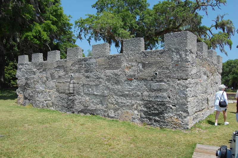
Fort Frederica National Monument on St. Simons Island, Georgia, preserves the remains of a fortified colonial town founded in 1736. The listed area includes tabby and brick foundations of houses, two storehouses, the King's Magazine, the Barracks ruins, a burial ground, the town moat and earthworks built in 1736 and 1739. It also covers the eight-acre Bloody Marsh Battle Site, five miles to the southeast. Frederica served as the hub of Georgia's defense against Spain. In 1742 it was headquarters for the forces that turned back a Spanish invasion during the War of Jenkin's Ear, and the fight at Bloody Marsh helped halt the advance. At its peak the town held about 1,500 people, including skilled craftsmen and soldiers of Oglethorpe's regiment. John and Charles Wesley preached there. After the regiment disbanded in 1749 and a fire in 1758, the soldiers withdrew in 1763 and the site was abandoned.
Significance in brief: Frederica was strategically the most important early settlement in Georgia and the hub of the colony's defense against the Spanish. In 1742 it was the headquarters of the forces that turned back a Spanish invasion during the War of Jenkin's Ear, and the Battle of Bloody Marsh was a major factor in halting that attempt. It was also a planned community where the Wesley brothers preached.
Machine-generated summary. This summary was generated by a language model from the official nomination document and has not been reviewed line by line by an editor. It may contain errors. Check the source document before relying on any detail. Source: nomination document (PDF) · National Archives catalog entry. NRHP reference 100005351, listed October 15, 1966. Summary generated October 2026 (model claude-sonnet-5-5, prompt v1.0-2026-10-29, confidence medium).
Key facts
| Address | Address restricted by the NPS (common for archaeological sites and some private homes) |
|---|---|
| County | Glynn County |
| Listed | October 15, 1966 |
| Reference number | 100005351 |
| Resource type | District |
| Period of significance | 18th Century |
| Areas of significance | Military, Social History |
| Level of significance | National |
| Status (as stated in the nomination) | Publicly owned and preserved by the National Park Service as a national monument with unrestricted public access; the structures are mostly foundations, ruins and earthworks, in unaltered condition on the original site. |
| Coordinates | 31.22312, -81.38928 (Wikidata) |
What listing means for this property
This is a historic district. Buildings within its boundary are either contributing (they add to the district's significance) or non-contributing. Owners of contributing income-producing buildings can claim the 20% federal rehabilitation tax credit; homeowners should look at state credits. National Register districts impose no design review by themselves; a local historic district ordinance, if one exists, does (the difference explained).
General information, not legal or tax advice. Rules change; confirm with your State Historic Preservation Office or a qualified adviser.
Sources and further reading
- National Park Service, National Register of Historic Places database (snapshot May 2026), reference 100005351.
- Nomination form (PDF, National Archives) — catalog entry
- Wikipedia article (used for cross-checking only; text not reproduced here)
- Wikidata Q1438527
- This listing as JSON
Last updated October 2026. Found an error? See the editorial policy for how to report it.