Etowah Mounds
Also known as: Etowah; Etowah Valley District

Why it's listed
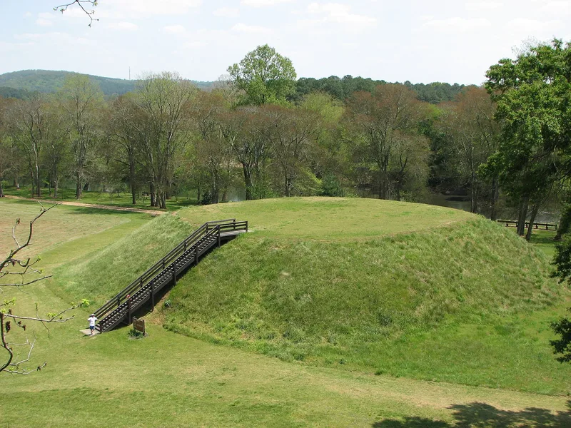
Etowah is a Mississippian town site on the north bank of the Etowah River near Cartersville, Georgia, where the river leaves the Piedmont and its valley widens into fertile floodplain. The site includes three large platform mounds, two plazas, a village area and a ditch that was once paralleled by a palisade. Mound A, the largest, covers several acres and rises roughly 50 to 65 feet. Excavations since the 1880s, especially in Mound C, have recovered hundreds of burials with copper-covered ear ornaments, engraved shell gorgets, mica cut-outs and two marble statues. Many objects carry designs of the Southeastern Ceremonial Complex, also called the Southern Cult. Archaeologists recognize Etowah, Wilbanks and Lamar phases of occupation, though dates remain debated. The site matters as a regional center showing Mississippian expansion into the east and as one of three major sources of evidence for the ceremonial complex. The mounds have been restored, and a state museum displays finds.
Significance in brief: The site was a Mississippian center serving smaller villages in the Etowah Valley and shows the eastward spread of Mississippian culture and its interaction with other Southeastern traditions. It has also produced a large quantity of elaborate ceremonial objects bearing designs of the Southeastern Ceremonial Complex (Southern Cult). It is one of three major sites in the country with extensive evidence of this complex.
Machine-generated summary. This summary was generated by a language model from the official nomination document and has not been reviewed line by line by an editor. It may contain errors. Check the source document before relying on any detail. Source: nomination document (PDF) · National Archives catalog entry. NRHP reference 66000272, listed October 15, 1966. Summary generated October 2026 (model claude-sonnet-5-5, prompt v1.0-2026-10-29, confidence medium).
Key facts
| Address | N bank of Etowah River, Cartersville |
|---|---|
| County | Bartow County |
| Listed | October 15, 1966 |
| Reference number | 66000272 |
| Resource type | Site |
| Period of significance | 1400-1499 checked; specific dates given as 1200 or 1350 to 1600 or 1650 |
| Areas of significance | Prehistoric |
| Level of significance | National |
| National Historic Landmark | Yes, designated July 19, 1964 |
| Status (as stated in the nomination) | Described as in good condition and owned by the State of Georgia; the mounds have been restored to a flat-topped, truncated pyramid form, and a state museum on site houses collections from the excavations. |
| Acreage | 170 |
| Coordinates | 34.12371, -84.80946 (NPS GIS) |
What listing means for this property
Sites (archaeological sites, battlefields, landscapes) are often listed with a restricted address to protect them from looting or disturbance. Listing is honorary for private owners; federal undertakings on or near the site go through Section 106 review, and state laws may protect burials and artefacts regardless of listing.
General information, not legal or tax advice. Rules change; confirm with your State Historic Preservation Office or a qualified adviser.
Sources and further reading
- National Park Service, National Register of Historic Places database (snapshot May 2026), reference 66000272.
- Nomination form (PDF, National Archives) — catalog entry
- Wikipedia article (used for cross-checking only; text not reproduced here)
- Wikidata Q4533107
- This listing as JSON
Last updated October 2026. Found an error? See the editorial policy for how to report it.