Weaverville Historic District
Also known as: Weaverville

Why it's listed
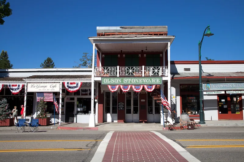
Weaverville's historic district covers about 11 acres on both sides of Main Street, running roughly 1,800 feet south from Garden Gulch. Around 25 buildings remain from the Gold Rush town named for John Weaver in 1850. Early wooden structures lost to repeated fires were replaced with brick, and by 1858 about 25 brick buildings lined Main Street. Several have upper and lower floors under separate ownership, reached by handmade outside spiral iron staircases. The district also includes the Trinity County Courthouse, built in 1856 and bought by the county in 1865, a drugstore operating since 1855, a bandstand from 1902, and Chinese tamped earth buildings from the 1860s. The Joss House, a Chinese temple rebuilt in 1874 after a fire, anchors the southern end. Weaverville served as the supply hub for miners across a large part of Northern California. Many buildings have been adapted for modern use but keep much of their original character.
Significance in brief: The nomination calls it probably one of the best preserved of the old Shasta-Trinity Gold Rush towns and the central historic zone of pioneer Weaverville. It served as the commercial, political and entertainment center of Trinity County. Distinctive features include the Chinese Joss House and brick buildings with separately owned upper and lower floors reached by outside spiral iron stairways.
Machine-generated summary. This summary was generated by a language model from the official nomination document and has not been reviewed line by line by an editor. It may contain errors. Check the source document before relying on any detail. Source: nomination document (PDF) · National Archives catalog entry. NRHP reference 71000209, listed October 14, 1971. Summary generated October 2026 (model claude-sonnet-5-5, prompt v1.0-2026-10-29, confidence medium).
Key facts
| Address | Both sides of Main St., Weaverville |
|---|---|
| County | Trinity County |
| Listed | October 14, 1971 |
| Reference number | 71000209 |
| Resource type | District |
| Period of significance | 19th Century |
| Architectural style | Gold Rush era commercial and residential buildings of Northern California mining towns, including brick, wood frame and Chinese tamped earth construction |
| Areas of significance | Commerce, Social History |
| Level of significance | State |
| Status (as stated in the nomination) | Most buildings are in good to excellent condition and some need restoration; some brick buildings have been stuccoed and others modified for current uses, which include shops, a hotel, a courthouse, a museum and a church. |
| Acreage | 11 |
| Coordinates | 40.73223, -122.94064 (NPS GIS) |
What listing means for this property
This is a historic district. Buildings within its boundary are either contributing (they add to the district's significance) or non-contributing. Owners of contributing income-producing buildings can claim the 20% federal rehabilitation tax credit; homeowners should look at state credits. National Register districts impose no design review by themselves; a local historic district ordinance, if one exists, does (the difference explained).
General information, not legal or tax advice. Rules change; confirm with your State Historic Preservation Office or a qualified adviser.
Sources and further reading
- National Park Service, National Register of Historic Places database (snapshot May 2026), reference 71000209.
- Nomination form (PDF, National Archives) — catalog entry
- Wikidata Q49577973
- This listing as JSON
Last updated October 2026. Found an error? See the editorial policy for how to report it.