Knights Ferry

Why it's listed
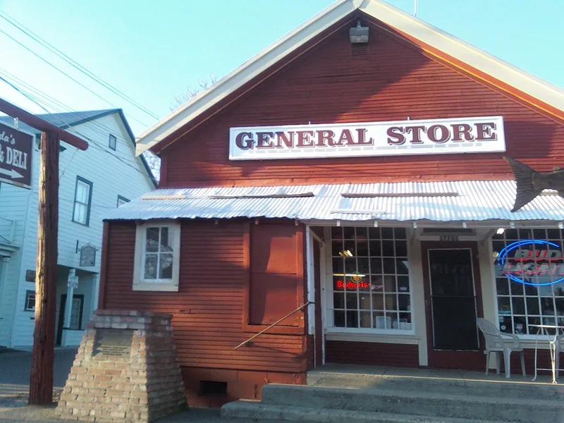
Knights Ferry is a small Gold Rush river town on the Stanislaus River, where the river leaves its canyon and heads toward the Central Valley. William Knight set up a trading post and ferry here, and gold traffic and nearby placer mining made it a major crossing and commercial center in the 1850s. It was the Stanislaus County seat from 1862 to 1872. Main Street and the terraced hillside behind it still hold buildings from that era, among them the hotel, the General Store operating since 1852, the Odd Fellows hall, Gothic Revival houses and two Classical Revival buildings built by Abraham Schell. At the east end stand the ruins of David Tulloch's 1862 stone grist mill beside the long covered bridge built after the 1862 flood. Floods, alterations and a few mobile homes have affected the setting, yet the district keeps much of the feeling of an early mining and trading town.
Significance in brief: The town was an important Gold Rush mining, trading and river-crossing center in the 1850s and served as Stanislaus County seat from 1862 to 1872. It keeps many buildings from the late 1850s and early 1860s, including Abraham Schell's Classical Revival buildings, Gothic Revival houses, the Tulloch grist mill ruins and the longest covered bridge in California. Together they present a relatively intact picture of a 19th-century river town.
Machine-generated summary. This summary was generated by a language model from the official nomination document and has not been reviewed line by line by an editor. It may contain errors. Check the source document before relying on any detail. Source: nomination document (PDF) · National Archives catalog entry. NRHP reference 75000490, listed April 23, 1975. Summary generated October 2026 (model claude-sonnet-5-5, prompt v1.0-2026-10-29, confidence medium).
Key facts
| Address | On Stanislaus River 2 mi. from Stanislaus, Knights Ferry and |
|---|---|
| County | Stanislaus County |
| Listed | April 23, 1975 |
| Reference number | 75000490 |
| Resource type | District |
| Architect / builder | Abraham Schell (Schell House and Masonic Hall); T. Vincent, stonemason (mill and bridge piers and abutments); David Tulloch (1862 grist mill); David Locke (first bridge) |
| Architectural style | Vernacular with Greek Revival and Gothic Revival elements; Classical Revival (Schell buildings) |
| Areas of significance | Other, Commerce, Politics/Government, Architecture |
| Level of significance | State |
| Status (as stated in the nomination) | Condition given as fair and altered, on its original site. The town is occupied and used for commercial, residential, park and agricultural purposes. The covered bridge still carries vehicle traffic, the grist mill is in ruins, and some mobile homes intrude on vacant lots. |
| Acreage | 107 |
| Coordinates | 37.82000, -120.66599 (NPS GIS) |
What listing means for this property
This is a historic district. Buildings within its boundary are either contributing (they add to the district's significance) or non-contributing. Owners of contributing income-producing buildings can claim the 20% federal rehabilitation tax credit; homeowners should look at state credits. National Register districts impose no design review by themselves; a local historic district ordinance, if one exists, does (the difference explained).
General information, not legal or tax advice. Rules change; confirm with your State Historic Preservation Office or a qualified adviser.
Sources and further reading
- National Park Service, National Register of Historic Places database (snapshot May 2026), reference 75000490.
- Nomination form (PDF, National Archives) — catalog entry
- Wikipedia article (used for cross-checking only; text not reproduced here)
- Wikidata Q1755284
- This listing as JSON
Last updated October 2026. Found an error? See the editorial policy for how to report it.