Point Conception Light Station
Also known as: Humqaq (Chumash Indian Nameplace)
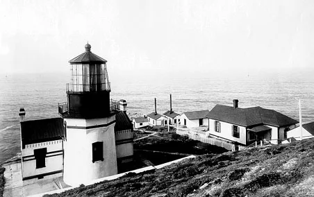

Why it's listed
Point Conception Light Station occupies 29.6 acres of windswept headland in Santa Barbara County. The district includes an 1881 white stuccoed brick keeper's dwelling with an attached 52-foot light tower that still uses its original lens, plus a coal house, a 1912 family quarters, a caretaker's residence, garages, a power house, a redwood water tank from 1881, and a fog horn. Mariners nicknamed the point "California's Cape Horn" for its rough waters, and Spanish navigators used it as a landmark. The first lighthouse, built by contractors Francis A. Gibbons and Francis X. Kelly, was finished in 1854 after the tower was rebuilt to meet an inspector's demands. It was first lit in February 1856. Cracking led to its replacement with the present tower, set lower on the point. A survey of the grounds also found 12 archaeological sites, including shell middens up to six feet deep, which add prehistoric significance.
Significance in brief: The nomination argues the point was a long-known landmark for mariners, called "California's Cape Horn," and was chosen for an early U.S. government lighthouse first lit in 1856. The present 1881 tower replaced the original 1854 structure. The grounds also contain 12 documented archaeological sites, including shell middens from earlier Indian occupation.
Machine-generated summary. This summary was generated by a language model from the official nomination document and has not been reviewed line by line by an editor. It may contain errors. Check the source document before relying on any detail. Source: nomination document (PDF) · National Archives catalog entry. NRHP reference 81000176, listed February 25, 1981. Summary generated October 2026 (model claude-sonnet-5-5, prompt v1.0-2026-10-29, confidence medium).
Key facts
| Address | U.S. Coast Guard Light Station, Santa Barbara |
|---|---|
| County | Santa Barbara County |
| Listed | February 25, 1981 |
| Reference number | 81000176 |
| Resource type | District |
| Architect / builder | Francis A. Gibbons and Francis X. Kelly (contractors for the original 1854 lighthouse) |
| Areas of significance | Prehistoric, Historic - Aboriginal, Transportation |
| Level of significance | National |
| Status (as stated in the nomination) | The 1912 family quarters is uninhabitable and boarded up. A caretaker lives on site and maintains the aids to navigation. The 1881 light still uses its original lens. |
| Acreage | 29 |
| Coordinates | 34.45055, -120.46931 (NPS GIS) |
What listing means for this property
This is a historic district. Buildings within its boundary are either contributing (they add to the district's significance) or non-contributing. Owners of contributing income-producing buildings can claim the 20% federal rehabilitation tax credit; homeowners should look at state credits. National Register districts impose no design review by themselves; a local historic district ordinance, if one exists, does (the difference explained).
General information, not legal or tax advice. Rules change; confirm with your State Historic Preservation Office or a qualified adviser.
Sources and further reading
- National Park Service, National Register of Historic Places database (snapshot May 2026), reference 81000176.
- Nomination form (PDF, National Archives) — catalog entry
- Wikipedia article (used for cross-checking only; text not reproduced here)
- Wikidata Q7207992
- This listing as JSON
Last updated October 2026. Found an error? See the editorial policy for how to report it.