Washington, Henry, Survey Marker

Why it's listed
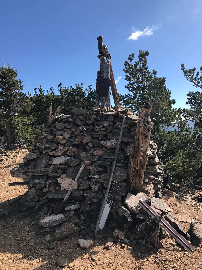
Located south of Big Bear City within the San Bernardino National Forest, this surveying monument is a pile of rocks about four feet high and thirty feet around, set between the remnants of three small pine trees. A hewn post installed by Deputy Surveyor Col. Henry Washington in November 1852 rises from the center; about eight feet of it still stands. Washington built it as the first initial point for the San Bernardino Base and Meridian, the starting point for dividing the lands of Southern California into sections. Later surveyors set two further initial points to the east in 1892 and 1907, and a federal engineer in 1917 accepted those two but not Washington's. The monument remains significant as the earliest initial point for the region's land surveys. Three of the four bearing trees Washington described still survive, and the site has changed little apart from a nearby trail and burn spots from 1949 bonfires.
Significance in brief: The monument was the first initial point built for the land surveys of Southern California, marking the start of the San Bernardino Base and Meridian. Two later initial points were set east of it in 1892 and 1907 because of survey errors. The form argues that Washington's point lies on the baseline and is part of the U.S. Public Land Survey.
Machine-generated summary. This summary was generated by a language model from the official nomination document and has not been reviewed line by line by an editor. It may contain errors. Check the source document before relying on any detail. Source: nomination document (PDF) · National Archives catalog entry. NRHP reference 75000459, listed May 12, 1975. Summary generated October 2026 (model claude-sonnet-5-5, prompt v1.0-2026-10-29, confidence medium).
Key facts
| Address | S of Big Bear City in San Bernadino National Forest, Big Bear City |
|---|---|
| County | San Bernardino County |
| Listed | May 12, 1975 |
| Reference number | 75000459 |
| Resource type | Object |
| Period of significance | 1852 |
| Architect / builder | Col. Henry Washington, Deputy Surveyor |
| Areas of significance | Community Planning and Development |
| Level of significance | Local |
| Status (as stated in the nomination) | Listed in good condition and described as unaltered and on its original site; about eight feet of the original post remains standing. Two of the three surviving bearing trees are in excellent condition and one is in poor condition. |
| Acreage | 2 |
| Coordinates | 34.12029, -116.93038 (NPS GIS) |
What listing means for this property
National Register listing is honorary: it recognises significance and does not restrict what a private owner may do without federal money or permits. It unlocks the 20% federal rehabilitation tax credit for income-producing buildings, state credits in many states, and Section 106 review when federal agencies are involved. See what listing means in practice.
General information, not legal or tax advice. Rules change; confirm with your State Historic Preservation Office or a qualified adviser.
Sources and further reading
- National Park Service, National Register of Historic Places database (snapshot May 2026), reference 75000459.
- Nomination form (PDF, National Archives) — catalog entry
- Wikipedia article (used for cross-checking only; text not reproduced here)
- Wikidata Q19868103
- This listing as JSON
Last updated October 2026. Found an error? See the editorial policy for how to report it.