Malakoff Diggins-North Bloomfield Historic District

Why it's listed
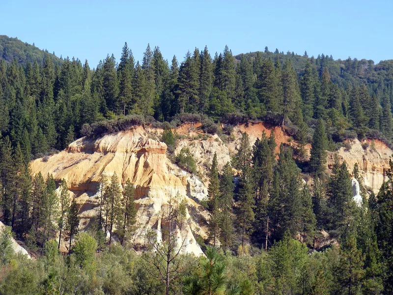
North Bloomfield and the adjoining Malakoff Diggins in Nevada County, California, form an 865-acre district that combines a surviving gold-mining town with the scarred landscape of hydraulic mining. The town began as a camp called Humbug in the early 1850s, was renamed Bloomfield and then North Bloomfield, and reached a peak population of 1,200 to 1,800 around 1880. Its wood-frame stores, houses, a livery stable, school, church and barn show the plain, high-roofed construction typical of the California gold regions. Among them is the 1852 McKillian and Mobley store, now a house museum furnished as an 1880s general store. Beyond town, cliffs up to 600 feet high remain from hydraulic operations that ran from 1866 to 1884, when anti-debris laws and the Sawyer decision ended the practice. By 1972 only about nine people lived in the town, and the area is now managed as a state historic park.
Significance in brief: The district preserves a mid-19th-century gold-region town of simple wood-frame homes and businesses beside the huge excavations left by hydraulic mining. It records the Gold Rush founding of the camp, the hydraulic mining era of 1866-1884, and its end through anti-debris laws and the Sawyer decision of 1884. The form also credits the eroded canyon landscape as a major environmental resource.
Machine-generated summary. This summary was generated by a language model from the official nomination document and has not been reviewed line by line by an editor. It may contain errors. Check the source document before relying on any detail. Source: nomination document (PDF) · National Archives catalog entry. NRHP reference 73000418, listed April 11, 1973. Summary generated October 2026 (model claude-sonnet-5-5, prompt v1.0-2026-10-29, confidence medium).
Key facts
| Address | Graniteville Star Route, North Bloomfield |
|---|---|
| County | Nevada County |
| Listed | April 11, 1973 |
| Reference number | 73000418 |
| Resource type | District |
| Architectural style | Simple frame vernacular buildings typical of California gold-region towns (board and batten, clapboard, channel rustic, little decoration) |
| Areas of significance | Industry, Commerce, Architecture, Social History |
| Level of significance | State |
| Status (as stated in the nomination) | State-owned park; condition of buildings ranges from excellent to poor. The McKillian and Mobley store is a house museum, Cummins Hall is a park office and museum, and several houses are described as fair or poor but reclaimable. |
| Acreage | 865 |
| Coordinates | 39.37097, -120.91327 (NPS GIS) |
What listing means for this property
This is a historic district. Buildings within its boundary are either contributing (they add to the district's significance) or non-contributing. Owners of contributing income-producing buildings can claim the 20% federal rehabilitation tax credit; homeowners should look at state credits. National Register districts impose no design review by themselves; a local historic district ordinance, if one exists, does (the difference explained).
General information, not legal or tax advice. Rules change; confirm with your State Historic Preservation Office or a qualified adviser.
Sources and further reading
- National Park Service, National Register of Historic Places database (snapshot May 2026), reference 73000418.
- Nomination form (PDF, National Archives) — catalog entry
- Wikipedia article (used for cross-checking only; text not reproduced here)
- Wikidata Q6741178
- This listing as JSON
Last updated October 2026. Found an error? See the editorial policy for how to report it.