Olema Lime Kilns

Approximate location: the National Park Service places this pin arbitrarily within the property, not at a surveyed point (stated accuracy ±12 m).
Why it's listed
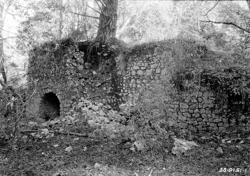
Three long-abandoned, barrel-shaped stone kilns lie in ruins against a hillside beside Olema Creek, south of Olema in Marin County, California. Built between 1850 and 1852, they formed a single structure about seventy feet long and sixteen feet high, with a low stone bin at the north end for storing burned lime. In 1850 James A. Shorb and William F. Mercer leased land from Rafael Garcia for burning lime, quarrying stone and cutting timber, hoping to supply a San Francisco swollen by the Gold Rush. Archeological evidence suggests the kilns were fired no more than about twelve times in all. Cheaper lime from other sources probably doomed the venture, which failed between 1853 and 1856. Douglas firs grew from the rubble, and stones were carried off for other uses. The kilns were listed as an early American attempt to build a lime industry in the region, though the business itself did not last.
Significance in brief: The kilns represent a Gold Rush-triggered, pioneer American effort to start a lime-producing industry in Marin County, only two years after California passed from Mexico to the United States. The enterprise was short-lived and unsuccessful, which the form says does not reduce its significance. It is described as regionally significant in the area of industry.
Machine-generated summary. This summary was generated by a language model from the official nomination document and has not been reviewed line by line by an editor. It may contain errors. Check the source document before relying on any detail. Source: nomination document (PDF) · National Archives catalog entry. NRHP reference 76000217, listed October 8, 1976. Summary generated October 2026 (model claude-sonnet-5-5, prompt v1.0-2026-10-29, confidence high).
Key facts
| Address | 4 mi. SE of Olema on CA 1, Olema |
|---|---|
| County | Marin County |
| Listed | October 8, 1976 |
| Reference number | 76000217 |
| Resource type | Structure |
| Period of significance | 1850-1852 |
| Architect / builder | James A. Shorb, William Mercer |
| Areas of significance | Industry |
| Level of significance | State |
| Status (as stated in the nomination) | Long-abandoned ruins in a park setting. The form lists the condition as excellent and the property as unoccupied. Kiln No. 3 has lost its arched entrance, and trees and vandalism have damaged the kilns. |
| Acreage | 0.9 |
| Within district | Olema Valley Dairy Ranches Historic District |
| Coordinates | 37.98839, -122.74715 (NPS GIS) |
What listing means for this property
National Register listing is honorary: it recognises significance and does not restrict what a private owner may do without federal money or permits. It unlocks the 20% federal rehabilitation tax credit for income-producing buildings, state credits in many states, and Section 106 review when federal agencies are involved. See what listing means in practice.
Noted as vacant in the nomination. Nomination documents can be decades old; current status may differ. If you are considering buying an empty listed property, read the due-diligence checklist.
General information, not legal or tax advice. Rules change; confirm with your State Historic Preservation Office or a qualified adviser.
Sources and further reading
- National Park Service, National Register of Historic Places database (snapshot May 2026), reference 76000217.
- Nomination form (PDF, National Archives) — catalog entry
- Wikipedia article (used for cross-checking only; text not reproduced here)
- Wikidata Q7086338
- This listing as JSON
Last updated October 2026. Found an error? See the editorial policy for how to report it.