Battery Osgood-Farley

Why it's listed
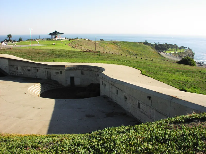
Battery Osgood-Farley is a concrete coastal gun emplacement on the Fort MacArthur Upper Reservation in San Pedro, overlooking the Pacific Ocean to the south. Land for the guns was acquired in 1910, construction started in 1912, and the battery was named in 1916 for Brigadier Generals Henry B. Osgood and Joseph P. Farley. It was finished in the fall of 1917. Built by cut-and-cover methods, it held two 14-inch disappearing carriage rifles behind 14-foot parapet walls, with an underground hub of shell and powder chambers, plotting rooms and power rooms. The roof is 9 feet thick under about 10 feet of earth. The nomination selected it as a representative piece of the harbor defense system of 1917 to 1947. Its heavy guns never fired in action, and by 1924 an inspecting general judged them too few and too short in range. The guns were sold as junk in 1946.
Significance in brief: The nomination presents the battery as a representative part of the coastal harbor defense system that existed from 1917 to 1947. It is a typical example of early twentieth-century fortification built for 14-inch disappearing carriage rifles. It also reflects the Army's changing defense priorities through both World Wars.
Machine-generated summary. This summary was generated by a language model from the official nomination document and has not been reviewed line by line by an editor. It may contain errors. Check the source document before relying on any detail. Source: nomination document (PDF) · National Archives catalog entry. NRHP reference 74000526, listed October 16, 1974. Summary generated October 2026 (model claude-sonnet-5-5, prompt v1.0-2026-10-29, confidence medium).
Key facts
| Address | Fort MacArthur Upper Reservation, San Pedro |
|---|---|
| County | Los Angeles County |
| Listed | October 16, 1974 |
| Reference number | 74000526 |
| Resource type | Structure |
| Period of significance | 1917-1947 |
| Areas of significance | Military, Engineering |
| Level of significance | National |
| Status (as stated in the nomination) | Condition is marked excellent and altered, on its original site. The standby generators are inoperable, and the guns were sold for junk in 1946. The form lists present use as park and military. |
| Acreage | 9.5 |
| Coordinates | 33.71169, -118.30713 (NPS GIS) |
What listing means for this property
National Register listing is honorary: it recognises significance and does not restrict what a private owner may do without federal money or permits. It unlocks the 20% federal rehabilitation tax credit for income-producing buildings, state credits in many states, and Section 106 review when federal agencies are involved. See what listing means in practice.
General information, not legal or tax advice. Rules change; confirm with your State Historic Preservation Office or a qualified adviser.
Sources and further reading
- National Park Service, National Register of Historic Places database (snapshot May 2026), reference 74000526.
- Nomination form (PDF, National Archives) — catalog entry
- Wikidata Q108874089
- This listing as JSON
Last updated October 2026. Found an error? See the editorial policy for how to report it.