Arroyo Seco Parkway Historic District
Also known as: Pasadena Freeway; State Route 110

Why it's listed
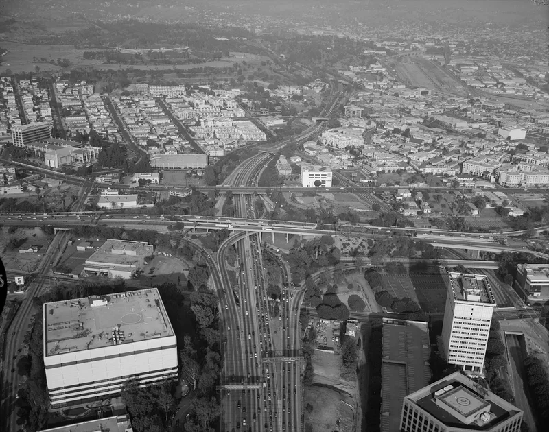
This 8.21-mile stretch of State Route 110, known as the Pasadena Freeway, links the Four Level Interchange in Los Angeles with East Glenarm Street in Pasadena. It was built in three phases: the first six miles in 1938-1940, the Southerly Extension in 1940-1943, and the last half-mile of bridges and interchange in 1948-1953. The district has 60 components, 45 of them contributing, including bridges, tunnels, pedestrian crossings, the Arroyo Seco Channel and two maintenance station buildings. Original features include concrete and asphalt paving, rubble retaining walls, native plantings and decorative bridge railings. Its significance rests on being the first grade-separated, limited-access, high-speed divided road in the urban western United States and the starting point of the Los Angeles freeway network. City Engineer Lloyd Aldrich assembled WPA, state gas tax and local support to build it. Apart from a short altered section, the parkway retains substantial integrity.
Significance in brief: The nomination presents the parkway as the first grade-separated, limited-access, high-speed divided road in the urban western United States and the first stretch of the Los Angeles freeway system. It also credits City Engineer Lloyd Aldrich's planning and his funding coalition of federal, state and local agencies. The district has 45 contributing resources, including bridges, tunnels, the Four Level Interchange and the roadway itself.
Machine-generated summary. This summary was generated by a language model from the official nomination document and has not been reviewed line by line by an editor. It may contain errors. Check the source document before relying on any detail. Source: nomination document (PDF) · National Archives catalog entry. NRHP reference 10001198, listed February 4, 2011. Summary generated October 2026 (model claude-sonnet-5-5, prompt v1.0-2026-10-29, confidence medium).
Key facts
| Address | CA 110 from 4-Level Interchange in Los Angeles to East Glenarm St in Pasadena, Los Angeles |
|---|---|
| County | Los Angeles County |
| Listed | February 4, 2011 |
| Reference number | 10001198 |
| Resource type | District |
| Architect / builder | Los Angeles Bureau of Engineering (Merrill Butler); California State Division of Highways; WPA work crews |
| Architectural style | Parkways; concrete rigid frame and arch spandrel bridges; Art Deco tunnel; vernacular pedestrian/equestrian tunnel |
| Areas of significance | Architecture, Engineering, Landscape Architecture |
| Level of significance | State |
| Status (as stated in the nomination) | Still in use as a highway. The only substantial alterations are between the Yale Street Pedestrian Overcrossing and the Stadium Way Overcrossing, which the form says caused about a 30% loss of integrity there. |
| Acreage | 162 |
| Coordinates | 17.92585, -116.37450 (NPS GIS) |
What listing means for this property
This is a historic district. Buildings within its boundary are either contributing (they add to the district's significance) or non-contributing. Owners of contributing income-producing buildings can claim the 20% federal rehabilitation tax credit; homeowners should look at state credits. National Register districts impose no design review by themselves; a local historic district ordinance, if one exists, does (the difference explained).
General information, not legal or tax advice. Rules change; confirm with your State Historic Preservation Office or a qualified adviser.
Sources and further reading
- National Park Service, National Register of Historic Places database (snapshot May 2026), reference 10001198.
- Nomination form (PDF, National Archives) — catalog entry
- Wikipedia article (used for cross-checking only; text not reproduced here)
- Wikidata Q460788
- This listing as JSON
Last updated October 2026. Found an error? See the editorial policy for how to report it.