The Forty Acres
Also known as: Delano Field Office; United Farm Workers

Why it's listed
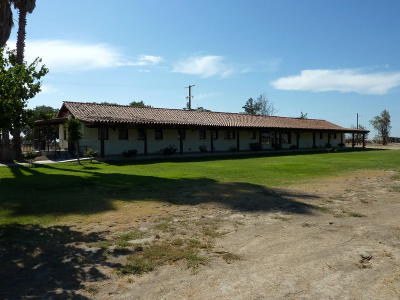
Forty Acres is a rural district at the corner of Garces Highway and Mettler Avenue, three miles west of Delano, California. In 1966 a farmworker organization bought the barren, alkali parcel beside the city dump and turned it into a service center and union headquarters. Between 1966 and 1974, volunteers and supporters, led by builder Richard Chávez, constructed an adobe service station, the steel-frame Roy L. Reuther Memorial Building, a health clinic and a fifty-nine-unit residential building. They also added a well, a tree-shaded park, a stone memorial, a recreational field and roads. Most buildings follow a modest Mission Revival design. The property matters as the base of César Chávez and the United Farm Workers during the table-grape strike and boycott, the first permanent agricultural labor union in the country. Chávez's first public fast took place at the service station, drawing national attention, and the union's work contributed to California's 1975 farm labor law.
Significance in brief: The Forty Acres served as headquarters of the first permanent agricultural labor union in the United States, the United Farm Workers. It is closely tied to César Chávez, the 1965-1970 table-grape strike and the Chicano Movement. Chávez's first public fast took place at the service station, and union members here worked toward the 1975 California Agricultural Labor Relations Act.
Machine-generated summary. This summary was generated by a language model from the official nomination document and has not been reviewed line by line by an editor. It may contain errors. Check the source document before relying on any detail. Source: nomination document (PDF) · National Archives catalog entry. NRHP reference 08001090, listed October 6, 2008. Summary generated October 2026 (model claude-sonnet-5-5, prompt v1.0-2026-10-29, confidence medium).
Key facts
| Address | 30168 Garces Highway, Delano |
|---|---|
| County | Kern County |
| Listed | October 6, 2008 |
| Reference number | 08001090 |
| Resource type | District |
| Architect / builder | Richard Chávez (builder); James Holland, contractor from Bakersfield (service station plans finalized) |
| Architectural style | Mission/Spanish Colonial Revival |
| Areas of significance | Economics, Social History, Hispanic, Pacific-Islander |
| Level of significance | National |
| National Historic Landmark | Yes, designated October 6, 2008 |
| Status (as stated in the nomination) | Current uses listed include meeting hall, multiple dwelling, park, monument/marker and outdoor recreation. |
| Acreage | 40 |
| Coordinates | 35.76379, -119.28795 (NPS GIS) |
What listing means for this property
This is a historic district. Buildings within its boundary are either contributing (they add to the district's significance) or non-contributing. Owners of contributing income-producing buildings can claim the 20% federal rehabilitation tax credit; homeowners should look at state credits. National Register districts impose no design review by themselves; a local historic district ordinance, if one exists, does (the difference explained).
General information, not legal or tax advice. Rules change; confirm with your State Historic Preservation Office or a qualified adviser.
Sources and further reading
- National Park Service, National Register of Historic Places database (snapshot May 2026), reference 08001090.
- Nomination form (PDF, National Archives) — catalog entry
- Wikipedia article (used for cross-checking only; text not reproduced here)
- Wikidata Q14684110
- This listing as JSON
Last updated October 2026. Found an error? See the editorial policy for how to report it.