Rogers Dry Lake
Also known as: Muroc Dry Lake

Why it's listed
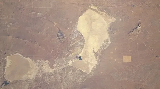
Rogers Dry Lake is a dry lakebed in the Antelope Valley of the Mojave Desert, inside Edwards Air Force Base in Kern County, California. Covering about sixty-five square miles, it is shaped like a lopsided figure-8 and has a clay surface hard enough to support the heaviest aircraft. It has about 60 miles of marked runways, forming the largest natural landing field in the world. The Army first used the area in 1933 for a bombing range. In 1942 the secret Bell XP-59A jet was tested there. Later, the lakebed hosted the Bell XS-1 supersonic flights of 1946-1947, the X-15 hypersonic research aircraft, and Space Shuttle landings, including Columbia in 1981. Its natural qualities of clean air, isolation, good weather and vast flat surface made it central to the development of American aeronautics and space flight. Lakebed Runways 18 and 23 are specifically recognized for the X-15 and Shuttle programs. The small settlement of Muroc that once stood on the shore no longer exists.
Significance in brief: The lake's hard, flat clay surface, clear air, isolated location and good weather drew the Army in 1933 and led to Edwards Air Force Base and the NASA Dryden Flight Research Facility. It was the site of landmark flight testing, from the Bell XS-1 supersonic flight to the X-15 and Space Shuttle landings. Lakebed Runways 18 and 23 are singled out for their ties to the X-15 and Shuttle programs.
Machine-generated summary. This summary was generated by a language model from the official nomination document and has not been reviewed line by line by an editor. It may contain errors. Check the source document before relying on any detail. Source: nomination document (PDF) · National Archives catalog entry. NRHP reference 85002816, listed October 3, 1985. Summary generated October 2026 (model claude-sonnet-5-5, prompt v1.0-2026-10-29, confidence medium).
Key facts
| Address | Edwards Air Force Base, Mojave Desert |
|---|---|
| County | Kern County |
| Listed | October 3, 1985 |
| Reference number | 85002816 |
| Resource type | Site |
| Period of significance | 1933 - Present |
| Areas of significance | Other, Military |
| Level of significance | National |
| National Historic Landmark | Yes, designated October 3, 1985 |
| Status (as stated in the nomination) | Listed as in excellent condition and altered; occupied, with restricted public access, and used for military, government, scientific and aerospace research purposes. |
| Acreage | 41000 |
| Coordinates | 34.96009, -117.84132 (NPS GIS) |
What listing means for this property
Sites (archaeological sites, battlefields, landscapes) are often listed with a restricted address to protect them from looting or disturbance. Listing is honorary for private owners; federal undertakings on or near the site go through Section 106 review, and state laws may protect burials and artefacts regardless of listing.
General information, not legal or tax advice. Rules change; confirm with your State Historic Preservation Office or a qualified adviser.
Sources and further reading
- National Park Service, National Register of Historic Places database (snapshot May 2026), reference 85002816.
- Nomination form (PDF, National Archives) — catalog entry
- Wikipedia article (used for cross-checking only; text not reproduced here)
- Wikidata Q1451247
- This listing as JSON
Last updated October 2026. Found an error? See the editorial policy for how to report it.