Harmony Borax Works
Also known as: Hs-2

Why it's listed
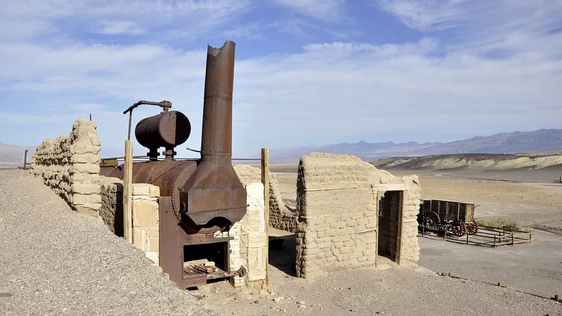
Harmony Borax Works is a 185-acre district of ruins at the mouth of Furnace Creek in Death Valley, California. Borax was found nearby in 1881, and San Francisco businessman W.T. Coleman began production around 1883 or 1884. Chinese laborers gathered the raw cottonball ore, and local Indians and some whites collected mesquite for fuel. The processing plant included a water system fed from Texas Spring, a boiler, a furnace, dissolving tanks and many cooling vats. Crystallized borax was sacked and hauled by mule-drawn wagons to the railhead at Mojave. The works closed in 1888 when Coleman's finances collapsed, and it later became part of the borax reserves of Pacific Coast Borax Company. The site is linked to the 20-mule team image, later used by Stephen T. Mather in sales promotion. Today only parts of the furnace, boiler, tanks and two adobe structures remain, forming the best preserved borax remains within the National Park Service.
Significance in brief: It was the birthplace, indirectly, of the 20-mule team symbol and a good example of a typical marsh borax operation. It also holds the best preserved remains of a borax operation within the National Park Service.
Machine-generated summary. This summary was generated by a language model from the official nomination document and has not been reviewed line by line by an editor. It may contain errors. Check the source document before relying on any detail. Source: nomination document (PDF) · National Archives catalog entry. NRHP reference 74000339, listed December 31, 1974. Summary generated October 2026 (model claude-sonnet-5-5, prompt v1.0-2026-10-29, confidence high).
Key facts
| Address | Death Valley National Monument, Stovepipe Wells |
|---|---|
| County | Inyo County |
| Listed | December 31, 1974 |
| Reference number | 74000339 |
| Resource type | District |
| Period of significance | 1883-1888 |
| Areas of significance | Industry, Commerce, Transportation |
| Level of significance | National |
| Status (as stated in the nomination) | Ruins, unaltered, on its original site; only part of the furnace, boiler, dissolving tanks, an adobe-walled structure and some wooden supports survive, along with parts of two adobe housing walls. |
| Acreage | 185 |
| Coordinates | 35.48760, -116.87477 (NPS GIS) |
What listing means for this property
This is a historic district. Buildings within its boundary are either contributing (they add to the district's significance) or non-contributing. Owners of contributing income-producing buildings can claim the 20% federal rehabilitation tax credit; homeowners should look at state credits. National Register districts impose no design review by themselves; a local historic district ordinance, if one exists, does (the difference explained).
Noted as vacant in the nomination. Nomination documents can be decades old; current status may differ. If you are considering buying an empty listed property, read the due-diligence checklist.
General information, not legal or tax advice. Rules change; confirm with your State Historic Preservation Office or a qualified adviser.
Sources and further reading
- National Park Service, National Register of Historic Places database (snapshot May 2026), reference 74000339.
- Nomination form (PDF, National Archives) — catalog entry
- Wikipedia article (used for cross-checking only; text not reproduced here)
- Wikidata Q129335
- This listing as JSON
Last updated October 2026. Found an error? See the editorial policy for how to report it.